United States. War Department. Corps of Engineers, cartographer, publisher
Published / Created:
[1881]
Call Number:
831 1881A
Image Count:
2
Resource Type:
cartographic image
Description:
Relief shown by hachures., Scale "1 inch - 12 miles.", Shows battle sites and military expeditions, with dates., Westernmost sheet: "2nd edition May 1875 compiled under direction of Capt. Wm. Ludlow, Corps of Engrs."--Lower left margin., and In upper left margin: Brig. Genl. A.A. Humphreys, Chief of Engineers.
BEIN BrSides Zc35 908un: Holes punched in margins.
Publisher:
Dept. of the Interior, General Land Office, Andrew B. Graham Co.)
Subject (Geographic):
Cheyenne River Indian Reservation (S.D.), Standing Rock Indian Reservation (N.D. and S.D.), South Dakota, Cheyenne River Indian Reservation., United States, and Standing Rock Indian Reservation.
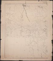
United States. War Department. Corps of Engineers, cartographer, publisher
Published / Created:
[1875?]
Call Number:
831 1875
Image Count:
1
Resource Type:
cartographic image
Description:
BEIN 831 1875: Imperfect: eastern sheet wanting; western sheet chipped. Inscription below edition statement: Lieut. [?] F. Eng., 5th Infty. Inscription on verso: Capt. Ludlow's map, 1875, sheet no. 1., Relief shown by hachures., Scale "1 inch - 12 miles.", Shows battle sites and military expeditions, with dates., and In upper left margin: Brig. Genl. A.A. Humphreys, Chief of Engineers.