Skip to search
Skip to main content
Skip to first result
Search
You Searched For
Genre
Maps
Publication Place
Paris
New Search
Search Results
Published / Created:
1902-03
Call Number:
2006 +236
Collection Title:
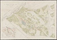
Exposition universelle internationale de 1900 a Paris : rapport general administratif et technique
Image Count:
1
Description:
Four plans, partly col., 90 x 130 cm. folded to 27 x 18 cm., in box with title: Exposition universelle international de 1900 a Paris ... plans generaux.
Publisher:
Imprimerie nationale
Subject (Geographic):
France
Subject (Name):
Exposition universelle internationale de 1900 (Paris, France)
Subject (Topic):
Colonial exhibitions. and Exhibition buildings
Found in:
Beinecke Rare Book and Manuscript Library > IV. Exposition universelle internationale de 1900. Enceinte urbaine. Plan general. Plan general
Creator:
Published / Created:
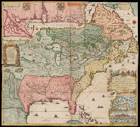
1718.
Call Number:
71 1718
Image Count:
2
Alternative Title:
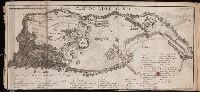
Le cours du Missisipi ou de St. Louis ...
Description:
Relief shown pictorially., Title from lower right cartouche., Originally in 4 sheets., Includes text and ill., and Insets: Les costes de la Louisiane de puis la Baye de l'Ascension jusques Acelle de St. Joseph ... Scale [ca. 1:1,000,000] -- Les environs de Québec -- Veüe de Québec.
Publisher:
Chez L'Auteur
Subject (Geographic):
North America, Mississippi River Delta (La.), Gulf Coast (Miss.), Gulf Coast (Ala.), and Québec Region (Québec)
Found in:
Beinecke Rare Book and Manuscript Library > La France Occidentale dans l'Amérique Septentrionale : ou le cours de la Rivière de St. Laurens, aux environs de la quelle se trouvent Le Canada, L'Acadie, et la Gaspasie, Les Esquimaux, Les Hurons, Les Iroquois, Les Illinois & La Virginie, La Marie-Lande, La Pensilvanie, Le Nouveau-Jersay, La Nouvelle Yorck, La Nouvelle Angleterre et l'Isle de Terre-Neuve
Published / Created:
1809
Call Number:
1978 +84
Collection Title:
Atlas portatif, contenant la géographie universelle ancienne et moderne ... composé de 49 cartes
Image Count:
1
Publisher:
Chez Desray, libraire
Collection Created:
A Paris, Chez Desray, libraire, 1809
Found in:
Beinecke Rare Book and Manuscript Library > La Grande Tartarie
Creator:
Published / Created:
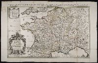
[1692?]
Call Number:
Folio 469
Collection Title:
[Atlas factice of 13 maps by Nicolaes Visscher I, Nicolaes Visscher II, Guillaume Sanson, and
Image Count:
1
Alternative Title:
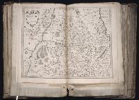
Royaume de France divise en toutes ses provinces
Publisher:
Chez H. Iaillot ... : Se vend a Amsterdam, chez le Freres Huguetan et chez Pierre Mortier ...
Subject (Geographic):
Europe --Maps --Early works to 1800 and France --Maps --Early works to 1800
Subject (Topic):
Atlases, Dutch --Early works to 1800
Found in:
Beinecke Rare Book and Manuscript Library > Le Royaume de France distingue suivant l’estenduee de toutes ses provinces et ses acquisitions [cartographic material] : dans l’Espagne, dans l’Italie, dans l’Allemagne, et dans la Flandre, l’Artois, le Haynaut, le Namur, et le Luxembourg, Provinces des P
Creator:
Published / Created:
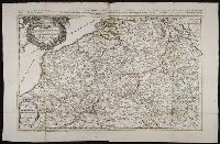
1691
Call Number:
Folio 469
Collection Title:
[Atlas factice of 13 maps by Nicolaes Visscher I, Nicolaes Visscher II, Guillaume Sanson, and
Image Count:
1
Alternative Title:
Provinces des Pays Bas catholiques, restees pour la plus part sous l’obeissance du roy d’Espagne
Publisher:
Chez H. Iaillot ... : Se vend a Amsterdam, chez le Freres Huguetan et chez Pierre Mortier ...
Subject (Geographic):
Benelux countries --Maps --Early works to 1800 and Europe --Maps --Early works to 1800
Subject (Topic):
Atlases, Dutch --Early works to 1800
Found in:
Beinecke Rare Book and Manuscript Library > Les Provinces des Pays-Bas catholiques [cartographic material] : distinguees suivant qu’elles sont presentement partagees entre le Roy de France, le Roy d’Espagne et les Estats Generaux des Provinces-Unies / presentees au Roy par ... Guillaume Sanson Geog
Creator:
Published / Created:
1796
Call Number:
GA405 +W44 (LC)
Collection Title:
Mapping the transmississippi West, 1540-1861
Image Count:
1
Description:
Bound in between p. 160-161. and Map 236 from table of contents.
Publisher:
Arthus Bertrand
Subject (Geographic):
Missouri River Valley--Maps, North America--Maps, and West (U.S.)--Maps
Collection Created:
San Francisco, Institute of Historical Cartography, 1957-63
Found in:
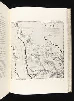
Beinecke Rare Book and Manuscript Library > Map of the Missouri; of the higher parts of the Mississippi; and of the elevated Plain, where the Waters divide, which run, Eastward into the River St. Lawrence; North East into Hudson's Bay; North North West into the Frozen Sea; and South into the Gulf o
Creator:
Published / Created:
[1653]
Call Number:
1983 Folio 19
Collection Title:
[Atlas factice of 96 maps by Blaeu, Visscher, Jansson, Hondius and others]
Image Count:
1
Description:
BEIN 1983 Folio 19: Sheet measures 39.1 x 51.2 cm. No. 24 of 92 maps bound together.
Publisher:
Pierre Mariette
Subject (Geographic):
Navarre (Kingdom) --Maps --Early works to 1800 and Navarre (Spain) --Maps --Early works to 1800
Collection Created:
[1556-1680]
Found in:
Beinecke Rare Book and Manuscript Library > Navarre
Branch:v1.64.3 ,Deployed:2024-09-25T10:53:04-04:00