Skip to search
Skip to main content
Skip to first result
Search
You Searched For
Genre
Maps
Publication Place
Paris :
New Search
Search Results
Published / Created:
1859
Call Number:
38 B64 1859
Container / Volume:
BRBL_00156
Image Count:
1
Resource Type:
Maps, Atlases & Globes
Description:
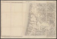
"Flle. 25".
Publisher:
Dépôt de la Guerre,
Subject (Geographic):
Aquitaine (France)--Maps
Subject (Name):
Dépôt de la guerre (France)
Found in:
Beinecke Rare Book and Manuscript Library > Bordeaux.
Published / Created:
1910
Call Number:
38 B83 1910
Container / Volume:
BRBL_00156
Image Count:
1
Resource Type:
Maps, Atlases & Globes
Description:
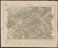
"Flle. XXXV-18".
Publisher:
Service Géographique de l'Armée,
Subject (Geographic):
Lorraine (France)--Maps
Found in:
Beinecke Rare Book and Manuscript Library > Bruyéres.
Published / Created:
[1850?]
Call Number:
844 1850A
Container / Volume:
BRBL_00601
Image Count:
1
Resource Type:
Maps, Atlases & Globes
Description:
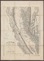
"Se vend à Paris, à l'Agence Nationale des Chemins de Fer et de la Navigation. 15, Place de Bourse. London, 16 Berners Street (Oxford Street)." and Relief shown by hachures and spot heights.
Publisher:
lith. mécanique de G. Trotignon, 6 r. de St. Quentin,
Subject (Geographic):
California--Gold discoveries--Maps and California--Maps
Subject (Name):
Girod, A, Pellée, and Trotignon, G
Subject (Topic):
Mines and mineral resources--California--Maps
Found in:
Beinecke Rare Book and Manuscript Library > Californie aurifère : carte officielle, dressée d'aprés les ordres du Sénat, après l'annexion de cette province aux États-Unis / A. Girod, invt. ; Pellée, delt.
Creator:
Published / Created:
[between 1916 and 1918?]
Call Number:
38 P21 1918
Container / Volume:
BRBL_00164A
Image Count:
1
Resource Type:
Maps, Atlases & Globes
Alternative Title:
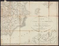
Nouveau plan de Paris et banlieue
Description:
"Imp. sur zinc, Monrocq, Paris.", Map shows streets, existing Metro lines, Metro lines under construction, "Ligne Nord-Sud," parks, and other points of interest in Paris., and National Library of France gives date as 1916. Handwritten note on map gives date as
Publisher:
E. Blondel la Rougery,
Subject (Geographic):
Paris (France)--Maps
Found in:
Beinecke Rare Book and Manuscript Library > Carte Campbell [cartographic material] : Nouveau plan de Paris et banlieue : Indiquant toutes les voies nouvelles ainsi que les lignes du Métropolitain et Nord-Sud exploitées ou en construction / Ed. Blondel la Rougery.
Branch:v1.61.6 ,Deployed:2024-06-12T09:55:33-04:00