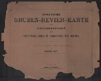
Geographical and Geological Survey of the Rocky Mountain Region (U.S.)
Published / Created:
1879?]
Call Number:
836ca 1879A
Container / Volume:
BRBL_00593
Image Count:
1
Resource Type:
Maps, Atlases & Globes
Description:
"Dept. of the Interior, U.S.G. and G. Survey, J.W. Powell in charge.", "Geology of the high plateaus of Utah, by Capt. C.E. Dutton, U.S.A.", and Appears in Topographical and geological atlas of the district of the high plateaus of Utah to accompany report of Capt. C.E. Dutton ... 1879. Atlas sheet no. 2.
Publisher:
U.S. G.P.O.?,
Subject (Name):
Dutton, Clarence E. (Clarence Edward), 1841-1912. Topographical and geological atlas of the district of the high plateaus of Utah and Geographical and Geological Survey of the Rocky Mountain Region (U.S.). Report on the geology of the high plateau
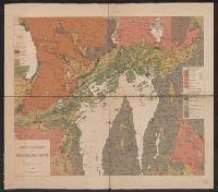
Karpinskiĭ, A. P. (Aleksandr Petrovich), 1846-1936
Published / Created:
1884
Call Number:
352ca Ur1 1884
Container / Volume:
BRBL_00109
Image Count:
3
Resource Type:
Maps, Atlases & Globes
Alternative Title:
Geologische Karte des Ostabhanges des Urals
Description:
Includes 2 inset maps: "Geologicheskai︠a︡ karta okrestnosteĭ S. Smolina" and "Geologicheskai︠a︡ karta dachi kamenskago zavoda.", Longitudinal coordinates shown on map are based on Pulkova., and Russian and German.
Accompanied by cover sheet with variant title: Geologis, Relief shown by contours and spot heights., Sheets 3, 4, and 6 thru 15 are map sheets. Geological cross-sections on sheets 1, 2, and 5; title and legend on sheet 16., and Title from title sheet (Blatt 16).
Publisher:
Alfred Hölder,
Subject (Topic):
Coal mines and mining--Czech Republic--Duchcov Region--Maps, Coal mines and mining--Czech Republic--Most Region--Maps, Coal mines and mining--Czech Republic--Teplice Region--Maps, and Mining geology--Czech Republic--Duchcov Re
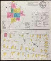
Fire insurance map, colored to show building construction, property boundaries and house and block numbers.
Alternative Title:
Georgetown, Del., Georgetown, Delaware, and Oct. 1919, Georgetown, Del.
Description:
"2866 (7 sheets).", Coordinates not present on map and are approximated., Includes index to streets and buildings., Sheet 1 includes key to building colors and other features of construction, water facilities and fire department, index map for the adjoining sheets., and Stamps on sheet 1: CLF 33812; Dec. 31, 1919.
Publisher:
Sanborn Map Company,
Subject (Geographic):
Georgetown (Del.)--Maps.
Subject (Topic):
Fire risk assessment--Delaware--Georgetown--Maps. and Real property--Delaware--Georgetown--Maps.