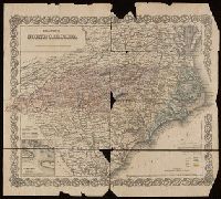
"Entered according to act of Congress in the 1855 by J.H. Colton & Co. ... for the Southern District of New York.", Imperfect: chipped and torn., Inset: Beaufort Harbor., Prime meridians: Greenwich and Washington., Relief shown by hachures and spot heights., and Shows counties, cities and towns, principal roads, railroads, and natural features. Colored to show tree types and mineral resources.
Publisher:
G.W. & C.B. Colton,
Subject (Geographic):
Beaufort (N.C.)--Maps, North Carolina--Beaufort, and North Carolina--Maps
Subject (Name):
J.H. Colton & Co
Subject (Topic):
Coal mines and mining--North Carolina--Maps, Copper mines and mining--North Carolina--Maps, Forests and forestry--North Carolina--Maps, Gold mines and mining--North Carolina--Maps, and Iron mines and mining--North C
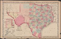
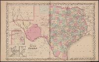
"No.35" and "No.36.", Includes Frio and Zavala counties which were formed in 1858 and which do not appear on Colton map dated 1857., Insets: Plan of the northern part of Te, and Library's copy annotated in pencil "This is in the same state as in the 1859 atlas."
Publisher:
Johnson & Browning,
Subject (Geographic):
Texas Panhandle (Tex.)--Maps, Texas--Administrative and political divisions--Maps, and Texas--Maps
Subject (Name):
De Cordova, Jacob, 1808-1868, J.H. Colton & Co, Johnson & Browning, and Streeter, Thomas W.--(Thomas Winthrop),--1883-1965--Ownership
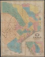
"Entered according to Act of Congress in the year 1839, by J.H. Colton, in the Clerks Office of the District Court of the Southern District of New York.", Library's copy annotated in pencil and orange ink., Prime meridians: Greenwich and Washington., and Relief shown by hachures.
Publisher:
J.H. Colton,
Subject (Geographic):
Texas--Administrative and political divisions--Maps and Texas--Maps
Subject (Name):
J.H. Colton & Co, Randel, Jesse F, and Stiles, Sherman & Smith
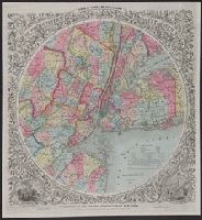
Colton, G. Woolworth (George Woolworth), 1827-1901
Published / Created:
1858, c1846.
Call Number:
771 N49 1858C
Container / Volume:
BRBL_00486
Image Count:
1
Resource Type:
Maps, Atlases & Globes
Description:
"Entered according to Act of Congress in t, Also shows county and township boundaries., Hand colored., Map withing decorative borders, including ills. of the New York and Brooklyn city halls., Margin title., and Relief shown by hachures. Depths shown by soundings.
Publisher:
J.H. Colton,
Subject (Geographic):
New Jersey--Administrative an dpolitical divisions--Maps, New York (State)--Administrative an dpolitical divisions--Maps, and New York Metropolitan Area--Maps
Subject (Name):
Atwood, John M., b. ca. 1818, Colton, J. H. (Joseph Hutchins), 1800-1893, and J.H. Colton & Co
"Compiled from J. De Cordova's large map.", "Entered according to act of Congress in the year 18[55?] by J.H. Colton & Co. in the clerks office of the district court of the United States for the southern district of New York.", "No.35" and "No. 36.", Includes Frio and Zavala counties which were formed in 1858., Insets: Plan of the northern part of Texas. Scale [ca. 1:3,800,000] -- Plan of Galveston Bay. Scale [ca. 1:1,036,987] -- Plan of Sabine Lake. Scale [ca. 1:500,000]., Prime meridians: Greenwich and Washington., Relief shown by hachures., Shows counties., and Text of "The state of Arkansas and the Indian Territory" on verso.
Publisher:
J.H. Colton & Co.,
Subject (Geographic):
Texas Panhandle (Tex.)--Maps, Texas--Administrative and political divisions--Maps, and Texas--Maps
Inset: Plan of the Port of Galveston / made by order of the Mexican government by Alexander Thompson of t and Unlike the later 1835 issue, shows Beals Grant south of Stephen E. Austin's Grant and does not show the towns of Columbia, Electa, Mina, and Augusta.
Publisher:
J.H. Colton & Co.,
Subject (Geographic):
Galveston Bay (Tex.)--Maps and Texas--Maps
Subject (Name):
J.H. Colton & Co, S. Stiles & Co, and Thompson, Alexander
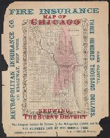
"Entered according to Act of Congress in the year 1855 by J.H. Colton & Co. in the Clerks Office of the District Court of the United States for the Southern District of New York." and Includes advertisements for Metropolitan Insurance Co. of New York printed in red over lower left portion of map.
Publisher:
G.W. & C.B. Colton,
Subject (Geographic):
Chicago (Ill.)--Maps
Subject (Name):
J.H. Colton & Co
Subject (Topic):
Fires--Illinois--Chicago--Maps and Great Fire, Chicago, Ill., 1871--Maps
"Entered according to Act of Congress in the year 1855 by J.H. Colton & Co. in the Clerks Office of the District Court of the United States for the Southern District of New York." and Includes advertisements for Metropolitan Insurance Co. of New York printed in blue surrounding map.
Publisher:
G.W. & C.B. Colton,
Subject (Geographic):
Chicago (Ill.)--Maps
Subject (Name):
J.H. Colton & Co
Subject (Topic):
Fires--Illinois--Chicago--Maps and Great Fire, Chicago, Ill., 1871--Maps
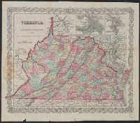
"Entered according to Act of Congress in the year 1855 by J.H. Colton & Co. in the Clerks Office of the District Court for the Southern District of New York.", Explanations: Rail Roads, Common, Canals, State Capital, County Towns, Vill. P.O. & Depots., and Map
Publisher:
Published by J.H. Colton & Co. No. 172 William Street,
Subject (Geographic):
Virginia--Maps--19th century and West Virginia--Maps--19th century