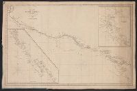
Includes insets of "Harbour of San Francisco, surveyed by Capt. F.W. Beechey" and the west coast from Port Venderas to San Francisco., Relief shown by hachures. Depths shown by soundings., and Shows route of "Corvetas Descubierta y Atrevida en 1791."
Publisher:
E. & G.W. Blunt,
Subject (Name):
Beechey, Frederick William, 1796-1856. Harbour of San Francisco
Subject (Topic):
Harbors--California--Monterey--Maps, Naut, Nautical charts--California, Nautical charts--California--Monterey Bay, Nautical charts--California--San Francisco Bay Area, and Nautical charts--Central America
Mexico. Dirección de Estudios Geográficos y Climatológicos
Published / Created:
[1922]
Call Number:
8894 1922
Container / Volume:
BRBL_00656
Image Count:
2
Resource Type:
Maps, Atlases & Globes
Description:
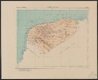
"No. 31.", Accompanied by physiographic plate covering same area, showing mainly relief and drainage (1 sheet : col. ; 48 cm.)., and Relief shown by shading. Depths by isolines.
Mexico. Dirección de Estudios Geográficos y Climatológicos
Published / Created:
[1922]
Call Number:
8814 1922
Container / Volume:
BRBL_00651
Image Count:
2
Resource Type:
Maps, Atlases & Globes
Description:
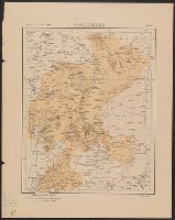
"No. 32.", Accompanied by physiographic plate covering same area, showing only relief and drainage (1 sheet : col. ; 60 cm.)., Appears in Atlas geográfico de la República mexicana., and Relief shown by shading.
Publisher:
La Dirección,
Subject (Geographic):
Zacatecas (Mexico : State)--Maps
Subject (Name):
Mexico. Dirección de Estudios Geográficos y Climatológicos. Atlas geográfico de la República Mexicana
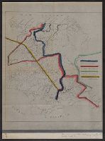
Boundary lines noted in hand-colored ink., Ms. notes along bottom right margin: "Taken from map without title, property of the United Fruit Co.", and Positive photostat.
From the Streeter collection., Pen-and-ink and watercolor., Relief shown by hachur, Shows "Partido del Paso," "Partido de Aldama," and "Partido de Rosales," with New Mexico to the north and Coahuila and Texas to the east., Spanish., and Title devised by cataloger.
Subject (Geographic):
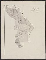
Chihuahua (Mexico : State)--Maps, Manuscript, Coahuila and Texas (Mexico)--Maps, Manuscript, and New Mexico--Maps, Manuscript
Luisiana, aņo de 1798, sur d'oueste de la ciudad. and Plano de la ciudad de Nueva Orleans.
Description:
"Luisiana, año de 1798, sur d'oueste de la ciudad," in French, Spanish and English, dated Marzo, 16 de 1798, and signed: Carlos Trudeau., "Plano de la ciudad de Nueva Orleans" in French and Spanish, dated 6 de Agosto 1799, and signed at end: Carlos Trudeau., At foot of map, "Luisiana, año de 1798 ... ": Recorded in the Book No. 3, page 216, New Orleans, juin 3th 1808. Van Pradelles ..., Maps are hand colored. Old fold marks visible., and Two folding plans of New Orleans by Charles Trudeau; to accompany Thierry's Examen des droits des Etats Unis ... , Nouvelle-Orleans, De l'imprimerie de Thierry & Co., 1808.
Publisher:
s.n.,
Subject (Geographic):
New Orleans (La.)--Maps
Subject (Name):
Thierry, J. B. S. (Jean Baptiste Simon), d. 1815. Examen des droits des Etats-Unis et des pretentions de Mr. Edouard Livingston sur la batture en face du faubourg Ste. Marie. and Thierry, J. B. S.--(Jean Baptiste Simon),--d. 1815.--Examen des droits des Etats-Unis et des pretentions de Mr. Edouard Livingston sur la batture en face du faubourg Ste. Marie.