Skip to search
Skip to main content
Skip to first result
Search
You Searched For
Extent of Digitization
Completely digitized
Genre
Maps
Language
Latin
New Search
Search Results
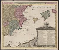
Creator:
Published / Created:
ca. 1750
Call Number:
1973 Folio 30
Collection Title:
[Atlas factice of 32 maps and 1 distance table, produced by the Homann Erben firm]
Image Count:
2
Publisher:
[Matthaeus Seutter?]
Subject (Geographic):
Dresden (Germany : Regierungsbezirk) --Maps --Early works to 1800
Subject (Topic):
Atlases, German --Early works to 1800
Collection Created:
[Nuremberg : s.n., 1701-1760]
Found in:
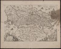
Beinecke Rare Book and Manuscript Library > Accuratissima delineatio geographica dioecesis ac praefecturae Dresdensis [cartographic material] : cujus urbes, oppida et pagi, loca item contermina, et quae in singulis notatu digniora videntur exactiori methodo geometrice designata sistuntur / per Matt
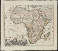
Creator:
Published / Created:
1700]
Call Number:
60 1700A
Container / Volume:
BRBL_00322
Image Count:
1
Resource Type:
Maps, Atlases & Globes
Alternative Title:
Africae tabula
Description:
Hand col. Sheet measures 58 x 66 cm., Includes ill. of ships and animals, and decorative cartouche., and Relief shown pictorially.
Publisher:
[s.n. ,
Subject (Geographic):
Africa--Maps--Early works to 1800
Subject (Name):
Homann, Johann Baptist, 1663-1724
Found in:
Beinecke Rare Book and Manuscript Library > Accuratissima totius Africae tabula / in lucem producta per Iacobum de Sandrart ; Joann. Bapt. Homann, sculpsit.
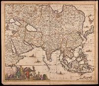
Creator:
Published / Created:
[1688?]
Call Number:
BrSides Double Folio 2018 10
Image Count:
1
Resource Type:
Maps, Atlases & Globes
Description:
Appears in various editions of Wit's Atlas., Hand colored in outline., Imperfect: chipped and torn along edges, with no loss of text. Backed with paper., Map of Asia from Saudi Arabia, Russia, India, China, Japan to Southeast Asia., Number "4" in upper right corner., and Relief shown pictorially.
Publisher:
[Frederik de Wit],
Subject (Geographic):
Asia--Maps--Early works to 1800.
Subject (Name):
Wit, Frederik de. Atlas.
Found in:
Beinecke Rare Book and Manuscript Library > Accuratissima totius Asiae tabula [cartographic material] : in omnes partes divisa, de nova correcta, ac in lucem edita / per Fredericum de Witt Amstelodami cum privilegio D.D. ordinum Hollandiae Westristacq[ue] ; F. de Wit excudit.
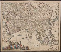
Creator:
Published / Created:
[approximately 1700?]
Call Number:
BrSides Double Folio 2019 68
Image Count:
1
Resource Type:
Maps, Atlases & Globes
Alternative Title:
Achaiae noua & accurata descriptio and Achaiae nova et accurata descriptio
Description:
Coordinates not present on map and are approximated., Includes four bar scales., Manuscript number in upper left corner: 30. Cardinal directions written in Latin manuscript along neat line., Relief shown pictorially., and Verso blank.
Publisher:
[Jan Jansson],
Subject (Geographic):
Achaia (Greece)--Maps--Early works to 1800.
Subject (Name):
Jansson, Jan, 1588-1664
Found in:
Beinecke Rare Book and Manuscript Library > Achaiae nova & accurata descriptio / autore I. Laurenbergio.
Published / Created:
1746
Call Number:
61 1746
Container / Volume:
BRBL_00330
Image Count:
1
Resource Type:
Maps, Atlases & Globes
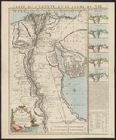
Description:
Insets: Ostia Nili Secundum-Herodotum, Strabonem, Diodorum, Plinium. Ptolemaeum. and Title at the top of map: Carte de L'Egypte et le Cours du Nil.
Publisher:
Apud Cóvens et Mortier,
Subject (Geographic):
Egypt--Maps--Early works to 1800
Found in:
Beinecke Rare Book and Manuscript Library > Aegypti ... I Condet S.
Creator:
Published / Created:
ca. 1720]
Call Number:
61 1700
Container / Volume:
BRBL_00330
Image Count:
1
Resource Type:
Maps, Atlases & Globes
Alternative Title:
Heutige Aegypten
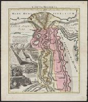
Description:
"Joannes Christophorus I.B. Homanni filius delineavit. Cum privilegio Sac. Caes. Majestatis.", Hand col. Sheet measures 65.5 x 56.5 cm., Includes illustrations of cataracts of the Nile, the pyramids, tombs, various antiquities, sce, and Relief shown by hachures.
Publisher:
[J.B. Homann,
Subject (Geographic):
Egypt--Maps--Early works to 1800
Found in:
Beinecke Rare Book and Manuscript Library > Aegyptus Hodierna : ex itinerario celeberrimi viri, Pauli Lucae Franci desumpta, ac novissime / repræsentata à Johanne Baptista Homann = das heutige Aegypten : aus der Reyssbeischreiburg des berühmten H.n Paul Lucas / gezogē, und mit folgenden Denkwur
Creator:
Published / Created:
1720?]
Call Number:
611 1720
Container / Volume:
BRBL_00331
Image Count:
1
Resource Type:
Maps, Atlases & Globes
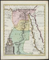
Description:
Covers region of Egypt and Sudan adjoining the Nile River., Includes decorative cartouche with ill. of coins., and Relief shown pictorially.
Publisher:
C. Weigel,
Subject (Geographic):
Egypt--Historical geography--Maps--Early works to 1800, Nile River Region--Historical geography--Maps--Early works to 1800, and Sudan--Historical geography--Maps--Early works to 1800
Found in:
Beinecke Rare Book and Manuscript Library > Aegyptus antiqua in suas partes et nomos divisa, cum Troglodytice, Marmarica, et Aethiopia supra Aegyptum / curante Christophoro Weigelio, Norimb[ergae].
Branch:v1.61.6 ,Deployed:2024-06-12T09:55:19-04:00