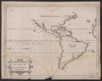
America, die newe Welt oder Inseln so hinder Hispania gegen Orient bey dem Landt Indie gelegen and Newen Inseln so hinder Hispaniam gegen Orient bey dem Landt Indie gelegen
Description:
Appeared in Münster's Cosmographia., Covers also the Pacific including New Guinea and Antarctica, i.e. Meridies terra del fuego., In the right-hand panel of text surmounting the map, the words Nova Francia appear in italic text rather than roman and the last word in the second line is Spanien., On verso: America, die newe Welt/ oder Inseln/ so hinder His-pania gegen Orient / bey dem Landt Indie gelegen. XXVI., Relief shown pictorially., Sheet measures 33.4 x 39.3 cm. Cross Collection no. 113., Text in German; place names in Latin or Spanish., and Title at top: Die newen Inseln/ so hinder Hispania gegen Orient/ bey dem Landt Indie gelegen.
Publisher:
s.n.,
Subject (Geographic):
America--Maps--Early works to 1800, Pacific Ocean--Maps--Early works to 1800, and Western Hemisphere--Maps--Early works to 1800
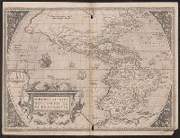
Caption title on verso: Die Newe Welt; numbered "2" in lower right corner., From a German edition of Ortelius's Theatrum orbis terrarum, published either 1572 or 1573., Imperfect: wormholes, with some loss of text. Sheet measures 39.8 x 52.3 cm. Cross Collection no. 111., Latin text on recto, German text on verso., and Relief shown pictorially.
Publisher:
s.n.,
Subject (Geographic):
America--Maps--Early works to 1800
Subject (Name):
Ortelius, Abraham, 1527-1598. Theatrum orbis terrarum. German
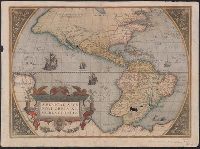
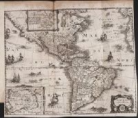
From Ortelius's Theatrum oder Schawbüch des Erdtkreijs [Antwerp : Christophe Plantin, Abraham Ortelius, 1580]., Latin and German., Several small holes in lower regions of South America where oxidized by pigment., Sheet measures 40 x 55 cm. Lanman Collection., Signature on verso: 5., Text on verso: Die newe Welt., and The viewer looks into the sails of the ship at 220 degrees of longitude.
Publisher:
Christophe Plantin, Abraham Ortelius,
Subject (Geographic):
America--Maps--Early works to 1800 and Western Hemisphere--Maps--Early works to 1800
Subject (Name):
Ortelius, Abraham, 1527-1598. Theatrum orbis terrarum. German and Plantin, Christophe, approximately 1520-1589
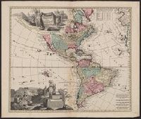
Includes ill., text, and table of latitudes and longitudes., Ms. no. on verso: No. 39. Label on verso [with ms. nos.]: 558/11. Sheet measures 55.5 x 66 cm. Cross Collection no. 122., Relief shown pictorially., and Shows California as an island.
Nova mappa geographica Americae Septentrionalis in suas praecipuas partes divisa
Description:
In French, with alternate title in Latin., Includes 18 insets and decorative cartouche., Prime meridians: Ferro and Paris., Relief shown pictorially., Title from upper margin., and Yale copy stamped on verso: Yale, Horace Brown, 1900S.
Publisher:
Sumptibus Ioh. Mich. Probst,
Subject (Geographic):
North America--Maps--Early works to 1800
Subject (Name):
Popple, Henry, -1743. Map of the British Empire in America and Probst, Jean George
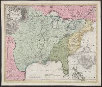
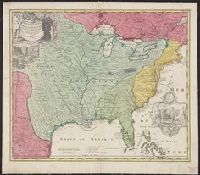
Appears in Homann Erben's Atlas geographicus major [1759 or 1763?]., Includes ill. and text., Relief shown pictorially., Some text in French., and Yale's card catalog notes "Fock catalogue no. 731 (fr. wh. acquired) gives date as ca. 1730"; and "In Homann J.B. Ne
Publisher:
[Homannianis heredibus?,
Subject (Geographic):
Louisiana--Maps--Early works to 1800 and North America--Maps--Early works to 1800
Subject (Name):
Hennepin, Louis, 17th cent and Homann Erben (Firm). Atlas geographicvs maior
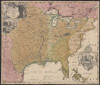
Includes ill. and text., Lowery refers to this version appearing in Homann's Atlas geographicvs maior exhibens tellurem seu globum terraqueum in mappis generalibus & specialibus ... (1759-[1781]), described in Phillips 622. Cf. Lowery 475., and Reference: Antiq
Publisher:
[s.n.,
Subject (Geographic):
Louisiana--Maps--Early works to 1800, Mississippi River Valley--Maps--Early works to 1800, and North America--Maps--Early works to 1800