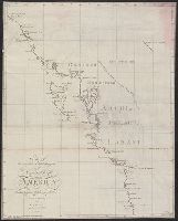
Compass arrow., Explanation of diagram from the five stand points of the Mobile fight / D.G. Farragut., Hand col., and Inset map: Points of collision of the different boats upon the Ram.
Publisher:
s.n.] ,
Subject (Geographic):
United States--History--Civil War, 1861-1865--Naval operations
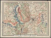
Bottom Margin: Bataille de Rezonville (16 Août 8h. du soir) -- Bataille de Gravelotte + St. Privat. (18 Août 7h du soir) -- Bataille de Borny (14 Août 8h du soir)., Coordinates not present on map and are approximated., Relief shown by hachures., and Troop locati
Publisher:
Hédin,
Subject (Geographic):
Moselle (France : 1790-1871)--Maps.
Subject (Topic):
Franco-Prussian War, 1870-1871--Campaigns--France, Eastern--Maps.
"Imprimerie xincographique du Service géographique de l'armée.", Includes key map., Relief shown by contours and shading., and Shows administrative boundaries, railways, roads, principal buildings named.
"Mai 1904.", Relief shown by shading and spot heights. Depths shown by soundings and bathymetric contours., and Shows Guandong Peninsula, southern Liaoning Sheng.
Publisher:
Service géographique de l'Armée,
Subject (Geographic):
Dalian Region (China)--Maps and Lüshun Region (China)--Maps