Geographical Section, General Staff ; no. 2149 and GSGS (Series) ; no. 2149.
Description:
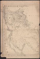
Map of Persia and Afghanistan showing international boundaries, transportation, communications, waterways and populated places. Relief shown by hypsometric tints, contours and spot heights.
Dedication signed: John Donne [the younger]., Imperfect: p. [1]-[4] mutilated; port. wanting. Samuel Taylor Coleridge's copy, with manuscript annotations in his hand (originally Charles Lamb's book which Coleridge apparently borrowed, see note on back board). Ms. notes by George T. Strong, of New York., Printer's name from Wing CD., Signatures: A⁴ B-2D⁸ (2D8, blank)., and With frontis. portrait (A1v) of John Donne.
Publisher:
In the Savoy, Printed by T[homas] N[ewcomb] for Henry Herringman, at the sign of the Anchor, in the lower-walk of the New-Exchange,
Subject (Name):
Coleridge, Samuel Taylor,--1772-1834--Autograph., Coleridge, Samuel Taylor,--1772-1834--Ms. notes., Donne, John, 1604-1662., Lamb, Charles,--1775-1834--Ownership., and Strong, George Templeton,--1820-1875--Ms. notes.
Great Britain. War Office. General Staff. Geographical Section
Published / Created:
1918
Call Number:
11hcf 1919D-3
Container / Volume:
BRBL_00010X
Image Count:
1
Resource Type:
Maps, Atlases & Globes
Alternative Title:
G.S.G.S. ; 3703a and GSGS (Series) ; 3703a.
Description:
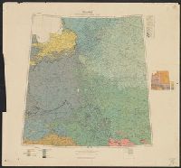
Includes chart "Population of certain towns," and index to adjoining maps in series. and Inset map: Density of population.
Publisher:
War Office [G.S.G.S.],
Subject (Topic):
Ethnology--Europe, Central--Maps, Ethnology--Europe, Eastern--Maps, Ethnology--Poland--Maps, Population density--Europe, Central--Maps, Population density--Europe, Eastern--Maps, and Population density--P