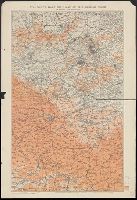
Edward Stanford Ltd. Stanford's war maps ; no. 17. and Stanford's war maps ; no. 17
Description:
"New edition, enlarged" printed in red above upper right margin. and Shows railways, roads, canals, and approximate position of Battle Front as of June 1916 and June 1917.
Publisher:
Edward Stanford Ltd.,
Subject (Geographic):
Belgium--Maps and France--Maps
Subject (Topic):
World War, 1914-1918--Campaigns--Western Front--Maps
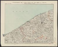
Ostend, Zeebrugge, Bruges, Stanford's war maps ; no. 23, and Stanford's war maps ; no. 23.
Description:
"August 1st, 1917.", Approximate line of battle front in June 1917 is shown with solid red line., Relief shown in gradient tints., and Shows railways, roads, canals, woods, lakes and marshes.
Publisher:
Edward Stanford,
Subject (Geographic):
Bruges (Belgium)--Maps, Ostend (Belgium)--Maps, West Flanders (Belgium)--Maps, and Zeebrugge (Belgium)--Maps
Subject (Topic):
World War, 1914-1918--Belgium--Bruges--Maps, World War, 1914-1918--Belgium--Ostend--Maps, World War, 1914-1918--Belgium--West Flanders--Maps, and World War, 1914-1918--Belgium--Zeebrugge--Maps
The Orange River Colony, the southern part of the Transvaal, the northern frontier of Cape Colony, Natal, Basutoland, and Delagoa Bay in Portuguese East Africa [cartographic material]
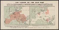
Compares the amount of territory occupied by the Allies versus that of the Central Powers., In lower margin: "If it is indeed true that the map is the test of Germany's success, then Germany has already irrevocably lost the war.", and Includes additional text.
Publisher:
Stanford's Geogl. Estabt.,
Subject (Geographic):
Europe--Administrative and political divisions--History--20th century--Maps, Europe--Maps, Germany--Administrative and political divisions--History--20th century--Maps, and Germany--Maps
Subject (Topic):
World War, 1914-1918--Europe--Maps and World War, 1914-1918--Germany--Maps