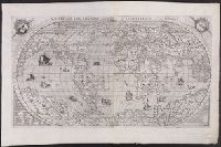
Vniversale descrittione di tvtta la terra conoscivta fin qvi
Description:
From: [Italian composite atlases]., Map is made from a new copper plate which is a close copy of Paolo Forlani's world map, which Forlani copied from Giacomo Gastaldi's prototype world map of 1546., Relief shown pictorially., and There are winged cherub heads in the top two spandrels.
Publisher:
Donato Bertelli,
Subject (Name):
Forlani, Paolo and Gastaldi, Giacomo, ca. 1500-ca. 1565
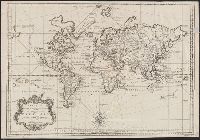
Cross collection no. 40., In lower right corner: "Tom VII No. 22.", Prime meridian: Paris., Relief shown pictorially., and Scale measured at center of hemisphere.
Publisher:
s.n.],
Subject (Name):
Maurepas, Jean-Frédéric Phélypeaux, comte de, 1701-1781
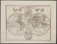
"C. Sepp del. et sculps. 1744.", Cross collection no. 37., In Dutch., Includes 2 smaller circular polar maps, and decorative cartouche., Mounted on linen., Ms. note at head of map: No. J., Relief shown pictorially., and Scale measured at center of hemisphere.
Cordiform projection., From: "Claudii Ptholemaei Alexandrini liber geographiae cum tabulis...", From: Clavdii Ptholemaei Alexandrini Liber geographiae cvm tabvlis...1511., Lanman collection; dgvmp2008., Map is printed in two colors, red and black., Outer map border shows decorative windheads and zodiacal signs., The author's name is often given as Bernard Sylvanus (see Shirley entry 32, plate 35) or Bernardus Sylvanus., and Title supplied by cataloger.
Publisher:
Per Iacobum Pentium de Leucho,
Subject (Name):
Pencio, Jacopo, active 1486-1530 and Ptolemy, active 2nd century. Geographia