Includes inset map showing congressional districts, rainfall, and soil types., Indexed "Gazetteer of Georgia" on verso., and Shows roads, agricultural schools and experiment stations, counties, and congressional districts.
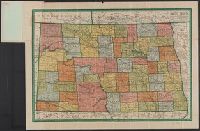
Complete map of N. Dakota, showing principal automobile roads, electric lines, railroads, M.O. postoffices, banks, rivers, canals, and last U.S. census of all towns and North Dakota
Description:
1910 census gazetteer of North Dakota on verso. and Relief shown by hachures.