Skip to search
Skip to main content
Skip to first result
Search
You Searched For
Genre
Atlases
Language
Latin
New Search
Search Results
Creator:
Published / Created:
1750
Call Number:
1973 Folio 30
Collection Title:
[Atlas factice of 32 maps and 1 distance table, produced by the Homann Erben firm]
Image Count:
2
Publisher:
[Matthaeus Seutter?]
Subject (Geographic):
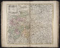
Nordhausen (Germany : Landkreis) --Maps --Early works to 1800
Subject (Topic):
Atlases, German --Early works to 1800
Collection Created:
[Nuremberg : s.n., 1701-1760]
Found in:
Beinecke Rare Book and Manuscript Library > Comitatus Stolbergensis delineatio geographia, Praefecturas Hohnstein, Stolberg, Hayn Berenroda, Ebersburg, Ufftrungen, Rosla et Questen cum limitibus et vicinia accurate exhibens / [cartographic material] / caelo Matthaei Seutteri. Georgraphi Caesarei ;
Creator:
Published / Created:
[1536?]
Call Number:
Covers 49 +1536
Image Count:
6
Resource Type:
cartographic image
Description:
Title devised by cataloger., Pen-and-ink in black, red, blue, green, and gold., Four charts, each measuring 33 x 43 cm, mounted on composite boards and edged with vellum, bound in boards covered by blue cloth with label pasted on front cover (No. [1906/242 in manuscript])., and Inscription on third chart (Mediterranean region from the Strait of Gibraltar to the coast of Greece), "Yhs ma [ver]go Conte freducci de ancona la facta nela[n]no MCCCCCXXXVJ."
Publisher:
Conte di Ottomano Freducci
Subject (Geographic):
Mediterranean Region, North Atlantic Ocean, and Baltic Sea
Subject (Topic):
Nautical charts and Maps
Found in:
Beinecke Rare Book and Manuscript Library > Composite atlas of portolan charts produced by Conte di Ottomano Freducci
Creator:
Published / Created:
1750
Call Number:
1973 Folio 30
Collection Title:
[Atlas factice of 32 maps and 1 distance table, produced by the Homann Erben firm]
Image Count:
2
Publisher:
[Matthaeus Seutter?]
Subject (Geographic):
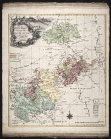
Saxony-Anhalt (Germany) --Maps --Early works to 1800
Subject (Topic):
Atlases, German --Early works to 1800
Collection Created:
[Nuremberg : s.n., 1701-1760]
Found in:
Beinecke Rare Book and Manuscript Library > Delineatio geographica comitatus Mansfeldensis ad jurisdictionem tum Saxonicam tum Brandenburgicam spectans, cum praefectura Sangerhusana, Querfurtensi, Sittenbacensi, Allstaedensi, et loci finitimis / [cartographic material] / cura Matth. Seutteri, Geogr
Creator:
Published / Created:
1720?
Call Number:
1975 Folio 31
Collection Title:
[Atlas factice of 42 maps, produced by the Homann Erben firm]
Image Count:
1
Publisher:
Johann Baptist Homann
Subject (Geographic):
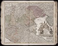
Italy, Northern --Maps --Early works to 1800 and Veneto (Italy) --Maps --Early works to 1800
Subject (Topic):
Atlases, German --Early works to 1800
Collection Created:
[Nuremberg,
Found in:
Beinecke Rare Book and Manuscript Library > Dominii Veneti cum vicinis Parmae, Mutinae, Mantuae, et Mirandolae statibus nova descriptio / [cartographic material] / edita a Ioh. Baptista Homanno, sacrae caes. majestatis geographo
Branch:v1.61.8 ,Deployed:2024-06-20T11:14:46-04:00