Skip to search
Skip to main content
Skip to first result
Search
You Searched For
Genre
Cadastral maps
Genre
Manuscript maps
Resource Type
Maps, Atlases & Globes
New Search
Search Results
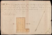
Creator:
Published / Created:
[1907]
Call Number:
BrSides Double Folio 2018 88
Image Count:
1
Resource Type:
Maps, Atlases & Globes
Description:
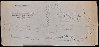
North oriented towards the left.
Subject (Geographic):
Oceanside (N.Y.)--Maps.
Subject (Name):
Davison, Lewis. and Davison, Tredwell.
Subject (Topic):
Real property--New York (State)--Oceanside--Maps.
Found in:
Beinecke Rare Book and Manuscript Library > Map of Meadow Land at Ocean side in the town of Hempstead Nassau County, N.Y. belonging to the estate of Lewis Davison Dec'd and the estate of Tredwell Davison dec'd / surveyed in March 1907, by DS Denton, Jr.
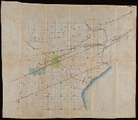
Creator:
Published / Created:
1912
Call Number:
802gbc P429 1912
Container / Volume:
BRBL_00717
Image Count:
1
Resource Type:
Maps, Atlases & Globes
Alternative Title:
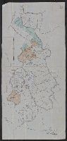
Map of Riverside Coal and Timber Co.
Description:
Coordinates not present on map and are approximated. and Note on verso, "Riverside T. Co. lands."
Subject (Geographic):
Perry County (Ky.)--Maps
Subject (Name):
Riverside Coal & Timber Company
Subject (Topic):
Coal trade--Kentucky--Perry County--Maps and Real property--Kentucky--Perry County
Found in:
Beinecke Rare Book and Manuscript Library > Map of Riverside Coal & Timber Co. : lands on Little Leatherwood C'r, Perry Co., Kentucky / J.C. Heydrick.
Creator:
Published / Created:
2nd Feby. 1877.
Call Number:
BrSides Double Folio 2018 97
Image Count:
1
Resource Type:
Maps, Atlases & Globes
Description:
Coordinates not present on map and are approximated., From the Richard H. Rickard Papers., and Title devised by cataloger.
Publisher:
Department of Crown Lands,
Subject (Name):
Ontario. Department of Crown Lands. and Rickard, Richard H.,---1885--Ownership.
Subject (Topic):
Mines and mineral resources--Ontario--Thunder Bay Region--Maps. and Real property--Ontario--Thunder Bay Region--Maps.
Found in:
Beinecke Rare Book and Manuscript Library > McIntyre / Thos. H. Johnson, Assistant Commissioner.
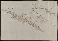
Published / Created:
[1811]
Call Number:
BrSides Folio 2018 145
Image Count:
1
Resource Type:
Maps, Atlases & Globes
Description:
Backed with linen., Manuscript number in lower right corner: 356., and Manuscript number on verso: 2170.
Subject (Geographic):
Milan (Italy)--Maps
Subject (Topic):
Land tenure--Italy--Milan--Maps and Real property--Italy--Milan--Maps
Found in:
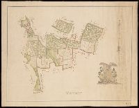
Beinecke Rare Book and Manuscript Library > Tipo de Beni di ragione del Signr. Cavaliere Giuseppe Branivilla situati in cassina nova comune di Carpiano Dipartino. d'Olana / rilevada e delineata dame ingegnere sollto. li 11 agosto 1811, M.B.
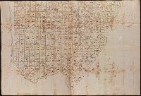
Creator:
Published / Created:
[1786]
Call Number:
BrSides Double Folio 2018 103
Image Count:
11
Resource Type:
Maps, Atlases & Globes
Description:
Manuscript number on verso of sheets: 2170. and Watermarks.
Subject (Name):
Cusani, Ferdinand and Ferrari, Carlo Francisco
Subject (Topic):
Land tenure--Italy--Milan--Maps--Early works to 1800., Real property--Italy--Milan--Maps--Early works to 1800., and Water-supply--Italy--Milan--Maps--Early works to 1800.
Found in:
Beinecke Rare Book and Manuscript Library > Tipo dimostrativo delle acque, cavi, edificij, e fondi cadenti rapporto alle loro colature sotto il contratto di transazione sequito fra l'illmo. Sig. Marchese Cusani Livellario delle acque di Lunico, ed uniti della misericordia unitamente a ssri. Carpane
Published / Created:
[1872?]
Call Number:
BrSides Folio 2018 141
Image Count:
1
Resource Type:
Maps, Atlases & Globes
Description:
From the Richard H. Rickard Papers., Illegible stamps with date "Mar 8 1872.", and Title devised by cataloger.
Subject (Name):
Rickard, Richard H.,---1885--Ownership.
Subject (Topic):
Mines and mineral resources--Ontario--Thunder Bay Region--Maps. and Real property--Ontario--Thunder Bay Region--Maps.
Found in:
Beinecke Rare Book and Manuscript Library > [Manuscript cadastral map of mine veins in Thunder Bay District, Canada].
Published / Created:
[after 1842]
Call Number:
BrSides Elephant Folio 2018 19
Image Count:
1
Resource Type:
Maps, Atlases & Globes
Description:
Coordinates not present on map and are approximated., Imperfect: mutilated., Relief shown by hachures., Shows government surveys with landowner and property boundaries drawn in., and Title devised by cataloger.
Subject (Geographic):
Maine--Maps
Subject (Topic):
Real property--Maine--Maps.
Found in:
Beinecke Rare Book and Manuscript Library > [Manuscript map of the northern third of Maine].
Published / Created:
[1872?]
Call Number:
BrSides Folio 2018 139
Image Count:
1
Resource Type:
Maps, Atlases & Globes
Alternative Title:
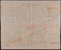
Map of Thunder Bay District, Canada, showing silver lands owned by Peter Mitchell and others
Description:
Accompanied by mailing envelope addressed in manuscript to R.H. Rickard., Coordinates not present on map and are approximated., From the Richard H. Rickard Papers., North oriented towards the upper right., and Title devised by cataloger from manuscript note on accompanying envelope.
Subject (Name):
Rickard, Richard H.,---1885--Ownership.
Subject (Topic):
Landowners--Ontario--Thunder Bay--Maps., Real property--Ontario--Thunder Bay--Maps., and Silver mines and mining--Ontario--Thunder Bay--Maps.
Found in:
Beinecke Rare Book and Manuscript Library > [Map of Thunder Bay District, Canada, showing silver lands owned by Peter Mitchell & others, Sept. 7th, 1872].
Branch:v1.61.8 ,Deployed:2024-06-20T11:15:02-04:00