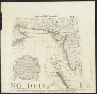
In french with long explanation of the use of letters in the margin for finding places mentioned in tables above and below map. Last date mentioned is 1685. and Preliminary record.
Appears in: Isolario, descrittione geografico-historica, sacro-profana...di tutte l'isole...del globo terracqueo / del P. maestro Vincenzo Coronelli, 1696. Parte II, p. 113., Appears to have, At head of page: Isolario del P. Coronelli., and In upper right: 113.
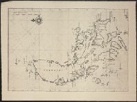
Depths shown by soundings., Includes text of "Expsication. La variation de l'aimant Estant sur legrand banc des terres neuues d'environs 22 degrez ...", Oriented with north towards upper right., and Shows Grand Banks of Newfoundland and "Partie de Terre Neuue."
Publisher:
se vant par Iaques Robin en la Rue du Pon neuf à Lenseigne du Pillote,
Subject (Geographic):
Grand Banks of Newfoundland--Maps--Early works to 1800 and Newfoundland, Island of (N.L.)--Maps--Early works to 1800
Subject (Name):
Robin, Iaques
Subject (Topic):
Nautical charts--Grand Banks of Newfoundland--Early works to 1800
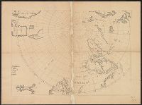
Cross Collection no. 60., From Janssonius's Niewen atlas ... Amstelodami : Apud Ioannem Ianssonium, 1652., Hand col. Mounted on linen., Includes marginal ill., Relief shown pictorially., Title supplied by cataloger., and Variant of Hondius' Polus Antarcticus, 1638.
Publisher:
J. Jansson,
Subject (Geographic):
Antarctica--Maps--Early works to 1800 and Southern Hemisphere--Maps--Early works to 1800