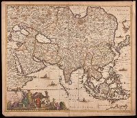
Appears in various editions of Wit's Atlas., Hand colored in outline., Imperfect: chipped and torn along edges, with no loss of text. Backed with paper., Map of Asia from Saudi Arabia, Russia, India, China, Japan to Southeast Asia., Number "4" in upper right corner., and Relief shown pictorially.
Achaiae noua & accurata descriptio and Achaiae nova et accurata descriptio
Description:
Coordinates not present on map and are approximated., Includes four bar scales., Manuscript number in upper left corner: 30. Cardinal directions written in Latin manuscript along neat line., Relief shown pictorially., and Verso blank.
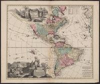
Includes ill., text, and table of latitudes and longitudes., Ms. no. on verso: No. 39. Label on verso [with ms. nos.]: 558/11. Sheet measures 55.5 x 66 cm. Cross Collection no. 122., Relief shown pictorially., and Shows California as an island.
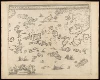
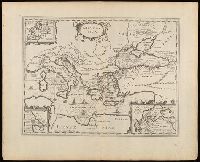
Archipelagi meridionalis, seu Cycladvm Insularum accurata delineatio
Description:
Includes three bar scales., Manuscript number in upper left corner: 33., Relief shown pictorially., and Verso blank.
Publisher:
[Jan Jansson],
Subject (Geographic):
Aegean Islands (Greece and Turkey)--Maps--Early works to 1800., Cyclades (Greece)--Maps--Early works to 1800., Dodecanese Islands (Greece)--Maps--Early works to 1800., and Sporades (Greece)--Maps--Early works to 1800.
Appeared in various editions of Jan Jansson's Accuratissima orbis antiqui delineatio., Includes three insets: Europa; Minoium pelagus; Propontis [Sea of Marmora]., Manuscript number in upper left corner: 24., Relief shown pictorially., and Verso blank.
Publisher:
[Jan Jansson],
Subject (Geographic):
Mediterranean Region--Maps--Early works to 1800.
Subject (Name):
Jansson, Jan, 1588-1664. Accuratissima orbis antiqui delineatio.
Subject (Topic):
Argonauts (Greek mythology)--Travel--Maps--Early works to 1800. and Literary landmarks--Mediterranean Region--Maps--Early works to 1800.
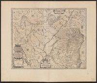
Appeared in Valk and Schenk's Atlantis sylloge compendiosa, ca. 1702., Backed with paper. Ms. no. "61" in upper right-hand corner. Sheet measures 53.1 x 62.3 cm. No. 56 of 87 maps bound together., Bar scales given in "milliaria Gallica" and "milliaria Germanica.", Prime meridian: Ferro., and Relief shown pictorially.
Publisher:
Ger. et Leo. Valk,
Subject (Geographic):
Orléanais (France)--Maps--Early works to 1800.
Subject (Name):
Schenk, Peter, 1660-1718 or 1719. Atlantis sylloge compendiosa., Valck, G. (Gerard), 1651 or 1652-1726. Atlantis sylloge compendiosa., and Valck, Leonard, 1675-1746.
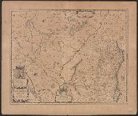
Britannia prout divisa fuit temporibus Anglo-Saxonum praesertim durante illorum heptarchia.
Description:
Border illustrations include seven Anglo-Saxon kings on the left; the conversion to Christianity of a further seven are depicted on the right., Manuscript number in upper left corner: 7., Relief shown pictorially., and Shows kingdom boundaries, rivers, settlements and shields.