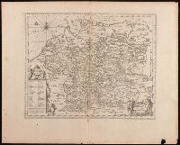
Keere, Pieter van den, 1571-approximately 1646, cartographer.
Published / Created:
[between 1652 and 1684]
Call Number:
BrSides Double Folio 2019 103
Image Count:
1
Resource Type:
Maps, Atlases & Globes
Description:
Appears in Jansson's historical atlas editions from 1652-1684., Manuscript number in upper left corner: 13., and Relief shown pictorially.
Publisher:
Apud Joannem Janssonium,
Subject (Geographic):
Benelux countries--Historical geography--Maps--Early works to 1800., Benelux countries--Maps--Early works to 1800., Europe, Central--Historical geography--Maps--Early works to 1800., and Europe, Central--Maps--Early works to 1
Subject (Name):
Jansson, Jan, 1588-1664, publisher.
Subject (Topic):
Ethnology--Europe--Maps--Early works to 1800. and Germanic peoples--Maps--Early works to 1800.
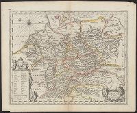
Appears in Jansson's historical atlas editions from 1652-1684., Hand colored., and Relief shown pictorially.
Publisher:
Apud Joannem Janssonium,
Subject (Geographic):
Benelux countries--Historical geography--Maps--Early works to 1800., Benelux countries--Maps--Early works to 1800., Europe, Central--Historical geography--Maps--Early works to 1800., Europe, Central--Maps--Early works to 1800., Europe, Eastern--Historical geography--Maps--Early works to 1800., Europe, Eastern--Maps--Early works to 1800., Germany--Historical geography--Maps--Early works to 1800., and Germany--Maps--Early works to 1800.
Subject (Name):
Jansson, Jan, 1588-1664
Subject (Topic):
Ethnology--Europe--Maps--Early works to 1800. and Germanic peoples--Maps--Early works to 1800.
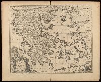
Appeared in various editions of Jan Jansson's Accuratissima orbis antiqui delineatio., Includes four bar scales., Relief shown pictorially., Verso blank., and Watermark. Manuscript number in upper left corner: 25.
Publisher:
[Jan Jansson],
Subject (Geographic):
Greece--Maps--Early works to 1800.
Subject (Name):
Jansson, Jan, 1588-1664. Accuratissima orbis antiqui delineatio.
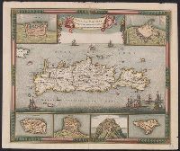
Bar scales given in "miliaria Italica communia" and "milliaria Germanica communia.", Hand colored. Manuscript number in upper right corner: 44., In upper right corner just above graticule: 22., Manuscript number in upper left corner: 26., Relief shown pictorially., and Verso blank.
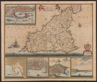
"23" in upper right corner., Appears in various editions of Wit's Atlas., Bar scale given in "milliaria Germanica"., Includes six insets: Canea; Candia; Spinalonga; Retimo; Thine; Suda., Relief shown pictorially., Watermark., and Without a watermark. Sheet measures
Appears in various editions of Wit's Atlas., Dedication: Amplissimo Doctissimoque Viro Domino Do. Joanni Uytenbogaert Jcto. nomine Illustrium et praepotent. DD. ordinum Hollandiae et Westvrisiae Aerary Publici Amstelodamensis Tribuno., and Includes col. ill., v
Publisher:
Gedruckt tot Amsterdam by Frederik de Wit inde Kalverstraet by den Dam inde Witte Paskaert,
Subject (Geographic):
Sicily (Italy)--Maps--Early works to 1800
Subject (Name):
Rodriguez, José M.--Bookplate, Uytenbogaart, J. W. H. (Johannes Wilhelmus Huybert), and Wit, Frederik de. Atlas
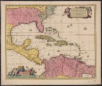
"Cum Privilegio Ordinum Hollandiae et Westfrisiae.", Appears in Visscher's Atlas minor., Includes scales in milliaria germanica, hispanica, and gallica., Mounted on linen. Sheet measures 51.5 x 61.8 cm. Cross Collection no. 238., Relief shown pictorially., and Shows the West Indies and Central America from Florida to the northern part of South America, including boundaries, settlements and rivers.
Publisher:
Nunc apud Petrum Schenk Junior,
Subject (Geographic):
Caribbean Area--Maps--Early works to 1800, Mexico, Gulf of--Maps--Early works to 1800, and West Indies--Maps--Early works to 1800
Subject (Name):
Schenk, Pieter, ca. 1698-1775 and Visscher, Nicolaes, 1649-1702. Atlas minor
Subject (Topic):
Coasts--North America--Maps--Early works to 1800 and Coasts--South America--Maps--Early works to 1800
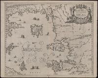
Insvlarvm archipelagi septentrionalis seu Maris Aegaei accurata delineatio
Description:
Coordinates not present on map and are approximated., Includes four bar scales., Manuscript number in upper left corner: 32., Relief shown pictorially., and Verso blank.
Publisher:
[Jan Jansson],
Subject (Geographic):
Aegean Islands (Greece and Turkey)--Maps--Early works to 1800.
Appeared in various editions of Jan Jansson's Accuratissima orbis antiqui delineatio., Coordinates not accurate as presented on map and are approximated., Relief shown pictorially., and Watermark. Manuscript number in upper left corner: 15.
Publisher:
[Jan Jansson],
Subject (Geographic):
Cisalpine Republic--Maps--Early works to 1800. and Lombardy (Italy)--Maps--Early works to 1800.
Subject (Name):
Jansson, Jan, 1588-1664. Accuratissima orbis antiqui delineatio. and Ortelius, Abraham, 1527-1598
Subject (Topic):
Historical geography--Italy--Lombardy--Maps--Early works to 1800.