Search
You Searched For
Search Results
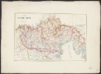
- Published / Created:
- 1865?
- Call Number:
- 466 1865
- Container / Volume:
- BRBL_00261
- Image Count:
- 1
- Resource Type:
- Maps, Atlases & Globes
- Description:
- Inset: Il Porto militare di Pola e l'Isola.
- Publisher:
- Vallardi,
- Subject (Geographic):
- Istria (Croatia and Slovenia)--Maps
- Found in:
- Beinecke Rare Book and Manuscript Library > Le Alpi Giulie, colle loro dipendenze italiane del Friuli Orientale ed Istria.
- Published / Created:
- [1860?]
- Call Number:
- 40 V545 1860
- Image Count:
- 1
- Resource Type:
- Maps, Atlases & Globes
- Description:
- In upper margin: Atlante Geografico dell'Italia
- Publisher:
- Dr. Francesco Vallardi, Tipografo-Editore,
- Subject (Geographic):
- Lazio (Italy)--Maps
- Found in:
- Beinecke Rare Book and Manuscript Library > Legazione di Velletri.
- Published / Created:
- [1855?]
- Call Number:
- 402 1855A
- Container / Volume:
- BRBL_00233
- Image Count:
- 1
- Resource Type:
- Maps, Atlases & Globes
- Description:
- Index indicates political divisions.
- Publisher:
- Ant. Vallardi,
- Subject (Geographic):
- Lombardy (Italy)--Maps and Veneto (Italy)--Maps
- Found in:
- Beinecke Rare Book and Manuscript Library > Lombardo - Veneto.
- Published / Created:
- 1857
- Call Number:
- 304gme 1857
- Container / Volume:
- BRBL_00035
- Image Count:
- 1
- Resource Type:
- Maps, Atlases & Globes
- Publisher:
- Litog. Corbetta,
- Subject (Geographic):
- Europe, Central--Maps
- Found in:
- Beinecke Rare Book and Manuscript Library > Nuovissima carta della strade ferrate nel Centro d'Europa (1857).
- Published / Created:
- 1858
- Call Number:
- 304gme 1858
- Container / Volume:
- BRBL_00035
- Image Count:
- 1
- Resource Type:
- Maps, Atlases & Globes
- Publisher:
- Litog. Corbetta,
- Subject (Geographic):
- Europe, Central--Maps
- Found in:
- Beinecke Rare Book and Manuscript Library > Nuovissima carta della strade ferrate nel Centro d'Europa (1858).
- Published / Created:
- 1825
- Call Number:
- 40 P28 1825
- Container / Volume:
- BRBL_00213
- Image Count:
- 1
- Resource Type:
- Maps, Atlases & Globes
- Description:
- Index, Views, (on the margins). and Preliminary record.
- Publisher:
- Presso Fernando Antaria,
- Subject (Geographic):
- Pavia (Italy)--Maps
- Found in:
- Beinecke Rare Book and Manuscript Library > Pianta ... di Pavia. Prada Unc.
- Published / Created:
- 1859
- Call Number:
- 40 Sp38 1859
- Image Count:
- 1
- Resource Type:
- Maps, Atlases & Globes
- Publisher:
- Francesco Vallardi,
- Subject (Geographic):
- Spezia, Gulf of (Italy)--Maps
- Found in:
- Beinecke Rare Book and Manuscript Library > Pianta del Golfo della Sepzia disegnata con la scorta de migliori materiali esistenti / Sotto la direzione di Carlo e Luigi Mezzacapo.