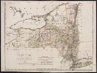
"W. Sander, sculp.", "Zu Ebelings Erdbeschreibung von Amerika.", Bar scales given in "Geographische Meilen oder ein Grad des Aequators" and "Englische meilen 69 4/25 auf einen Grad.", In upper right margin: No. VII., Place names in English and German., Prime meridians: Greenwich and Washington., Relief shown by hachures., Sheet measures 51.5 x 68.9 cm., Shows county and some township boundaries., and Watermark.
Publisher:
Bey Carl Ernst Bohn,
Subject (Geographic):
New York (State)--Administrative and political divisions--Maps--Early works to 1800 and New York (State)--Maps--Early works to 1800
Subject (Name):
Bohn, Carl Ernst, Ebeling, Christoph Daniel,--1741-1817--Presentation inscription to N. Webster, Ebeling, Christophe Daniel, 1741-1817. Erdbeschreibung und Geschichte von Amerika, and Sander, Wilhelm, 1766-1836, engraver
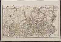
"W. Sander sc.", "Zu Ebelings Erdbeschreibung von Amerika.", Also shows county boundaries., Bar scales given in "Geographische Meilen 15 auf einen Grad" and "Englische meilen 69 4/25 auf einen Grad.", In upper right margin: No. IX., Place names in German and English., Prime meridians: Greenwich and Washington., Relief shown by hachures., Sheet measures 51 x 73.3 cm. Franklin Collection no. 131 1797 1., and Watermark.
Publisher:
Bey Carl Ernst Bohn,
Subject (Geographic):
Pennsylvania--Administrative and political divisions--Maps--Early works to 1800 and Pennsylvania--Maps--Early works to 1800
Subject (Name):
Bohn, Carl Ernst, publisher, Ebeling, Christophe Daniel, 1741-1817. Erdbeschreibung und Geschichte von Amerika, and Sander, Wilhelm, 1766-1836, engraver
Bohn, Carl Ernst, publisher Ebeling, Christophe Daniel, 1741-1817. Erdbeschreibung und Geschichte von Amerika Sander, Wilhelm, 1766-1836, engraver Sotzmann, D. F
Published / Created:
1797
Call Number:
1977 Folio 177
Image Count:
2
Resource Type:
Maps, Atlases & Globes
Description:
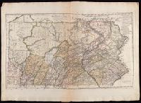
"W. Sander sc.", "Zu Ebelings Erdbeschreibung von Amerika.", Also shows county boundaries., Bar scales given in "Geographische Meilen 15 auf einen Grad" and "Englische meilen 69 4/25 auf einen Grad.", In upper right margin: No. IX., Place names in German and English., Prime meridians: Greenwich and Washington., Relief shown by hachures., Sheet measures 53.9 x 74.7 cm. No. 3 of 34 maps bound together., and Watermark.
Publisher:
Bey Carl Ernst Bohn,
Subject (Geographic):
Pennsylvania--Administrative and political divisions--Maps--Early works to 1800 and Pennsylvania--Maps--Early works to 1800
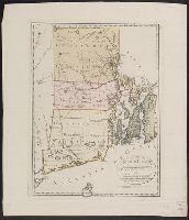
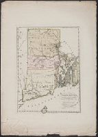
"Zu Ebelings Erdbeschreibung von Amerika.", Bar scales given in "Geographische Meilen 15 auf einen Grad" and "Englische meilen 69 4/25 auf einen Grad.", Hand col. Sheet measures 59.8 cm., In upper right margin: No. V., Prime meridians: Greenwich an, and Watermark.
Publisher:
Bey Carl Ernst Bohn,
Subject (Geographic):
Rhode Island--Administrative and political divisions--Maps--Early works to 1800 and Rhode Island--Maps--Early works to 1800
Subject (Name):
Bohn, Carl Ernst, Ebeling, Christophe Daniel, 1741-1817. Erdbeschreibung und Geschichte von Amerika, and Kliewer, Heinrich, engraver
"Zu Ebelings Erdbeschreibung von Ameri, Bar scales given in "Geographische Meilen 15 auf einen Grad" and "Englische meilen 69 4/25 auf einen Grad.", Imperfect: mutilated and repaired on bottom, with no loss of text. Sheet measures 76.0 x 54.2 cm., and Watermark.
Publisher:
Bey Carl Ernst Bohn,
Subject (Geographic):
Rhode Island--Administrative and political divisions--Maps--Early works to 1800 and Rhode Island--Maps--Early works to 1800
Subject (Name):
Bohn, Carl Ernst, Ebeling, Christophe Daniel, 1741-1817. Erdbeschreibung und Geschichte von Amerika, and Kliewer, Heinrich, engraver
Above neat line at right: Festschrift der Hamburghischen Amerika feier II, taffel 1., BEIN 90475 1892: Manuscript note., From Hamburgische festschrift zur erinnerung an die entdeckung Amerika's, 1892., Printed facsimile of manuscript map in British Library., and Shows Guiana coast from mouth of Amazon westward.
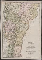
"Zu Ebelings Erdbeschr, Also shows county boundaries., In upper right margin: No. XVI., Place names in German and English., Prime meridians: Greenwich and Washington., Relief shown by hachures., and Sheet measures 72.4 x 50.5 cm. Franklin Collection no. 131 1796 1.
Publisher:
Bey Carl Ernst Bohn,
Subject (Geographic):
Vermont--Administrative and political divisions--Maps--Early works to 1800 and Vermont--Maps--Early works to 1800
Subject (Name):
Bohn, Carl Ernst, publisher, Ebeling, Christophe Daniel, 1741-1817. Erdbeschreibung und Geschichte von Amerika, and Schmidt, Paulus, engraver
"Zu Ebelings Erdbeschreibung von Amerika.", Also shows county boundaries., In upper right margin: No. XVI., Place names in German and English., Prime meridians: Greenwich and Washington., Relief shown by hachures., and Sheet measures 74.9 x 54.1 cm. Ms. no.: L.C. 9