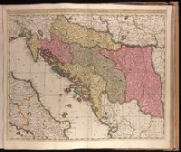
Backed with paper. Ms. no. "77" in upper right corner. Sheet measures 53.6 x 62.5 cm. No. 71 of 87 maps bound together., Bar scales given in "milliaria Hungarica" and "milliaria Germanica.", Covers Croatia, Bosnia and Hercegovina, Serbia, Montenegro and portions of Italy, Albania, Greece, Macedonia and Hungary., In Latin with place names in Italian., and Relief shown pictorially.
Langren, Arnold Florent van, 1580-1644, cartographer
Published / Created:
[1638]
Call Number:
90 1638
Container / Volume:
BRBL_00661
Image Count:
1
Resource Type:
Maps, Atlases & Globes
Description:
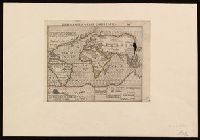
From Jan Huygen van Linschoten's Histoire de la navigation de Iean Hvgves de Linschot Hollandois., Oriented with north to the right., Relief shown pictorially., and Watermark.
Publisher:
[Evert Cloppenburgh],
Subject (Geographic):
South America--Maps--Early works to 1800
Subject (Name):
Linschoten, Jan Huygen van, 1563-1611. Histoire de la navigation de Iean Hvgves de Linschot Hollandois
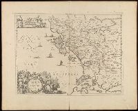
Imperfect: two small holes at upper right corner where oxidized by pigment. Label on verso with manuscript number "550/149." Cross collection no. 6. Mounted on paper., In Latin on verso with caption title "Itinerarivm B. Pavli.", and In top right margin: 675.
Dimidia Tribvs Manasse ultra Jordanem, tribus Neptalim et partes orientales Tribuum Zabvion et Isachar
Description:
Appears in Jansson's historical atlas editions from 1652-1684 and in his Accuratissima orbis antiqui delineatio. From 1653 on, this work is known under the name of Hornius, who wrote the text and compiled all the maps for the atlases--(Koeman-Krogt. 1:601-1:607)., Coordinates not present on map and are approximated., Inset: Peregrinatio Abrahae., Map indexed with grid lines and alphabet letters P-R at top., Oriented with north toward the left., Printed on one and a half sheets., Relief shown pictorially., and Watermark. Manuscript numbers in upper left and right corners: 46. No. 4 of 6 maps housed together.
Publisher:
[Jan Jansson],
Subject (Geographic):
Palestine--History--To 70 A.D.--Maps--Early works to 1800. and Palestine--Maps--Early works to 1800.
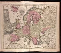
"Cum privilegio Amsteld. et Regis Poloniae .", Backed with paper. Ms. no. "3" in upper right-hand corner. Sheet measures 53.4 x 62.0 cm. No. 2 of 87 maps bound together., Includes two insets showing the path of the solar eclipse of May 12, 1706., Prime meridian: Ferro., and Relief shown pictorially.
Publisher:
Á Petro Schenk,
Subject (Geographic):
Europe--Maps--Early works to 1800.
Subject (Name):
Moolen, Simon van de. and Schenk, Peter, 1660-1718 or 1719.
Cross Collection no. 350., From Jodocus Hondius's Appendix Atlantis majoris. [Amsterdam] : Per Iodocum Hondium, 1630., Imperfect: mutilated along fold at bottom, with no loss of text. Mounted on linen., Map of the Straits of Magellan, South America., Relief shown pictorially., and Title in Latin; place names in Dutch.
Publisher:
Judocus Hondius excudit,
Subject (Geographic):
Magellan, Strait of (Chile and Argentina)--Maps--Early works to 1800
Subject (Name):
Gryp, Dirck, engraver and Hondius, Jodocus, 1594 or 1595-1629. Appendix Atlantis majoris
Bar scales in "Miliaria Germanica communia" and "Miliaria Gallica communia.", From Blaeu's Le theatre du monde ... Amsterdami : Apud Guiljelmum et Iohannem Blaeu, 1635., In French on verso, with caption title "Le Destroict de Magellanes, & celuy de la Maire" and signature 7L., and Relief shown pictorially.
Publisher:
Guiljelmus Blaeuw excudit,
Subject (Geographic):
Magellan, Strait of (Chile and Argentina)--Maps--Early works to 1800
Subject (Name):
Blaeu, Joan, 1596-1673. Theatrum orbis terrarum. French, Blaeu, Willem Janszoon, 1571-1638. Theatrum orbis terrarum. French, and Gryp, Dirck, engraver
Keere, Pieter van den, 1571-approximately 1646, cartographer.
Published / Created:
[between 1652 and 1684]
Call Number:
BrSides Double Folio 2019 103
Image Count:
1
Resource Type:
Maps, Atlases & Globes
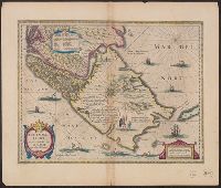
Description:
Appears in Jansson's historical atlas editions from 1652-1684., Manuscript number in upper left corner: 13., and Relief shown pictorially.
Publisher:
Apud Joannem Janssonium,
Subject (Geographic):
Benelux countries--Historical geography--Maps--Early works to 1800., Benelux countries--Maps--Early works to 1800., Europe, Central--Historical geography--Maps--Early works to 1800., and Europe, Central--Maps--Early works to 1
Subject (Name):
Jansson, Jan, 1588-1664, publisher.
Subject (Topic):
Ethnology--Europe--Maps--Early works to 1800. and Germanic peoples--Maps--Early works to 1800.
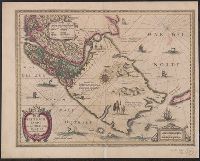
Appears in Jansson's historical atlas editions from 1652-1684., Hand colored., and Relief shown pictorially.
Publisher:
Apud Joannem Janssonium,
Subject (Geographic):
Benelux countries--Historical geography--Maps--Early works to 1800., Benelux countries--Maps--Early works to 1800., Europe, Central--Historical geography--Maps--Early works to 1800., Europe, Central--Maps--Early works to 1800., Europe, Eastern--Historical geography--Maps--Early works to 1800., Europe, Eastern--Maps--Early works to 1800., Germany--Historical geography--Maps--Early works to 1800., and Germany--Maps--Early works to 1800.
Subject (Name):
Jansson, Jan, 1588-1664
Subject (Topic):
Ethnology--Europe--Maps--Early works to 1800. and Germanic peoples--Maps--Early works to 1800.