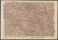
"Front au 1er. Janvier 1916.", "Supplément à l'illustration.", Ms. note outside bottom right margin "L'illus My'19"., and Shows location of Western Front, railways, roads, canals, borders, and fortifications.
Bumstead, Albert H. (Albert Hoit), 1875-1940 National Geographic Society (U.S.). Cartographic Division
Published / Created:
1918
Call Number:
30 1918B
Container / Volume:
BRBL_00032A
Image Count:
1
Resource Type:
Maps, Atlases & Globes
Alternative Title:
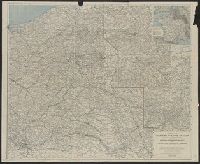
Index to the map of the Western Theatre of War.
Description:
Detached from: National Geographic, May 1918., Indexed by: Index to the map of the Western Theatre of War., and Inset: "Showing relation of the Western Theatre of War to the surrounding region and the connection of the two sections of the main map."
Publisher:
The Society,
Subject (Geographic):
Alsace (France)--Maps, Europe--Maps, and Lorraine (France)--Maps
Subject (Topic):
World War, 1914-1918--Belgium--Maps, World War, 1914-1918--France--Maps, and World War, 1914-1918--Maps
Bumstead, Albert H. (Albert Hoit), 1875-1940 National Geographic Society (U.S.). Cartographic Division
Published / Created:
1918
Call Number:
11hc 1918C
Container / Volume:
BRBL_00010E
Image Count:
1
Resource Type:
Maps, Atlases & Globes
Alternative Title:
Index to the map of the Western Theatre of War.
Description:
Detached from: National Geographic, May 1918., Indexed by: Index to the map of the Western Theatre of War., and Inset: "Showing relation of the Western Theatre of War to the surrounding region and the connection of the two sections of the main map."
Publisher:
The Society,
Subject (Geographic):
Alsace (France)--Maps, Europe--Maps, and Lorraine (France)--Maps
Subject (Topic):
World War, 1914-1918--Belgium--Maps, World War, 1914-1918--France--Maps, and World War, 1914-1918--Maps
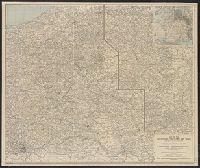
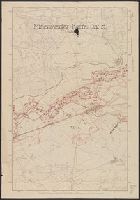
Area: from Baltic Sea to Innsbruck ; from Luxemburg to Warsaw., Imperfect. Cover wanting, some text lost., Includes index., and Shows: camps and hospitals for British prisoners, towns, rivers and roads.
Publisher:
Nisbet & Co.,
Subject (Geographic):
Austria--Maps and Germany--Maps
Subject (Topic):
World War, 1914-1918--Maps and World War, 1914-1918--Prisoners and prisons, German--Maps
Royal Geographical Society (Great Britain). Geographical Section, cartographer
Call Number:
11hcf 1919E-23
Container / Volume:
BRBL_00010ZA
Image Count:
1
Resource Type:
Maps, Atlases & Globes
Alternative Title:
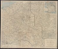
Europe 1:1,000,000, G.S.G.S. ; no. 2758, and GSGS (Series) ; no. 2758.
Description:
Elevation shown by color., Includes index to adjoining sheets, index to boundaries, and pronunciation glossary., and Sheet "North L-33, Triest," from same series, attached. Label pasted at foot of sheet showing "Treaty of London line" and "Recommended southern
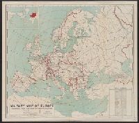
Includes table showing area and populations of the European powers., Indicates fortified towns, military headquarters, naval stations, railroads; concentric circl, Inset of location map of the world with Europe highlighted in red., and Prime meridian: Greenwich.
Publisher:
General Drafting Co.,
Subject (Geographic):
Europe--Maps
Subject (Topic):
World War, 1914-1918--Europe--Maps and World War, 1914-1918--Maps