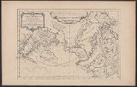
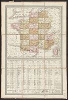
From La Rochefoucauld-Liancourt's Voyage dans les Etats Unis d'Amerique fait en 1795, 1796 et 1797. Paris : Chez Du Pont ... Buisson ... Charles Pougens ..., [1799], Relief shown by hachures., Sheet measures 43 x 46 cm., and Title in French and place
Publisher:
Chez Du Pont, Imprimeur-Libraire ...,
Subject (Geographic):
United States--Maps--Early works to 1800
Subject (Name):
La Rochefoucauld-Liancourt, François-Alexandre-Frédéric, duc de, 1747-1827. Voyage dans les Etats Unis d'Amerique fait en 1795, 1796 et 1797
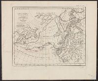
Has watermarks., Prime meridian: Ferro., and Relief shown pictorially.
Publisher:
[s.n.],
Subject (Geographic):
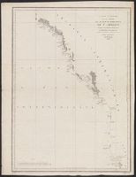
Arctic regions--Discovery and exploration--Maps--Early works to 1800, Arctic Regions--Maps--Early works to 1800, North Pacific Ocean--Maps--Early works to 1800, and Northwest Passage--Maps--Early works to 1800
La Pérouse, Jean-François de Galaup, comte de, 1741-1788
Published / Created:
{1797]
Call Number:
845 1797
Container / Volume:
BRBL_00619
Image Count:
1
Resource Type:
Maps, Atlases & Globes
Description:
Appears in the author's Atlas du voyage de La Pérouse. 1797., Has watermark., In bottom right margin: no 16., Prime meridian: Paris., and Relief shown by hachures.
Publisher:
L'imprimerie de la république,
Subject (Geographic):
Northwest Coast of North America--Maps--Early works to 1800
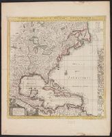
Subject (Name):
Arnold, Robert M.--Ownership, Bouclet, Hérault, La Pérouse, Jean-François de Galaup, comte de, 1741-1788. Atlas du voyage de La Pérouse, and Le Paute d'Agelet, Joseph, 1751-ca. 1786
Includes list of abbreviations, decorative cartouche, compass rose and 18 insets., Map attributed to Le Rouge based on reference in W.P. Cumming's Southeast in early maps, no. 216, p. 199., Prime meridians: Paris and London., and Yale's copy stamped: Yale, Horac
Publisher:
Chez Crepy rue St. Jacques à St. Pierre près la rue de la Parcheminerie,
Subject (Geographic):
Great Britain--Colonies--America--Maps--Early works to 1800 and North America--Maps--Early works to 1800
Subject (Name):
Crépy (Firm) and Popple, Henry, -1743. Map of the British Empire in America, with the French and Spanish settlements adjacent thereto