Skip to search
Skip to main content
Skip to first result
Search
You Searched For
Extent of Digitization
Completely digitized
Format
cartographic
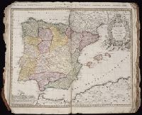
Subject (Topic)
Atlases, German --Early works to 1800
New Search
Search Results
Creator:
Published / Created:
1742?
Call Number:
1975 Folio 31
Collection Title:
[Atlas factice of 42 maps, produced by the Homann Erben firm]
Image Count:
1
Alternative Title:
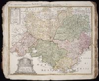
Praefectura Generalis et Comitatus Provinciae
Subject (Geographic):
Alpes de Haute-Provence (France) --Maps --Early works to 1800, Alpes-Maritimes (France) --Maps --Early works to 1800, Bouches-du-Rhone (France) --Maps --Early works to 1800, France, Southern --Maps --Early works to 1800, Var (France) --Maps --Early works to 1800, and Vaucluse (France : Dept.) --Maps --Early works to 1800
Subject (Topic):
Atlases, German --Early works to 1800
Collection Created:
[Nuremberg,
Found in:
Beinecke Rare Book and Manuscript Library > Praefectura Generalis & Comitatus Provinciae una cum Terris adjacentibus in suas Dioeceses & Praeturas subdivisus ad prototypum del Islianum / [cartographic material] / excusus studion Homannianorum Heredum
Creator:
Published / Created:
ca. 1715
Call Number:
1975 Folio 31
Collection Title:
[Atlas factice of 42 maps, produced by the Homann Erben firm]
Image Count:
1
Publisher:
Johann Baptist Homann
Subject (Geographic):
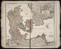
Denmark --Maps --Early works to 1800
Subject (Topic):
Atlases, German --Early works to 1800
Collection Created:
[Nuremberg,
Found in:
Beinecke Rare Book and Manuscript Library > Regni Daniae, in quo sunt Ducatus Holsatia et Slesvicum, insulae Danicae, provinciae Iutia, Scania, Bleckingia, nova tabula / [cartographic material] / edita a Io. Baptista Homanno ; et aucta secundum geographiam novissimam Iohann Huebneri, I.U.L
Creator:
Published / Created:
173-?
Call Number:
1973 Folio 30
Collection Title:
[Atlas factice of 32 maps and 1 distance table, produced by the Homann Erben firm]
Image Count:
2
Publisher:
[Johann Baptist Homann]
Subject (Geographic):
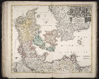
Denmark --Maps --Early works to 1800
Subject (Topic):
Atlases, German --Early works to 1800
Collection Created:
[Nuremberg : s.n., 1701-1760]
Found in:
Beinecke Rare Book and Manuscript Library > Regni Daniae, in quo sunt Ducatus Holsatia et Slesvicum, insulae Danicae, provinciae Iutia, Scania, Bleckingia, nova tabula [cartographic material] / edita a Io. Baptista Homanno ; et aucta secundum geographiam novissimam Iohann Huebneri, J.U.L
Branch:v1.61.8 ,Deployed:2024-06-20T11:14:55-04:00