Skip to search
Skip to main content
Skip to first result
Search
You Searched For
Date
Unknown
Resource Type
Maps, Atlases & Globes
Language
French
Date Created
[Missing]
New Search
Search Results
Creator:
Call Number:
70 1865
Container / Volume:
BRBL_00359
Image Count:
1
Resource Type:
Maps, Atlases & Globes
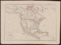
Description:
" Atlas Général par J. Dussieux, 134"., From Dussieux Atlas Général., and Relief shown pictorially.
Subject (Geographic):
North America--Maps
Subject (Name):
Dussieux, L. (Louis), 1815-1894 . Atlas Général
Found in:
Beinecke Rare Book and Manuscript Library > Carte physique et politique de L'Amerique Septentrionale / par L. Dussieux, 1865.
Creator:
Call Number:
11 1784
Container / Volume:
BRBL_00006
Image Count:
1
Resource Type:
Maps, Atlases & Globes
Description:
"On ignore si dans celle Parlie ce sont des Terres ou des Mers.", Cartouche in right lower corner: Avertissement., In right lower margin: Prix un Franc det demi., Plate 4, vol. 2 from Jacques Nicolas Bellin's Hydrographie françoise., Prime meridia, and Watermark.
Subject (Geographic):
World maps--Early works to 1800
Found in:
Beinecke Rare Book and Manuscript Library > Carte réduite des parties connues du globe terrestre : dressée au dépost des cartes plans et journaux de la marine pour le service des vaisseaux du roy / par ordre de M. de Machault ... MDCCLV.
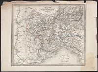
Creator:
Call Number:
3635 1752
Collection Title:
Atlas universel
Container / Volume:
BRBL_00142
Image Count:
1
Resource Type:
Maps, Atlases & Globes
Description:
Illustrated cartouche., Relief shown pictorially., and Stamp on verso: 67.Sheet: 50.6 x 66.3 cm.
Subject (Geographic):
Germany, Northern--Maps--Early works to 1800 and Lower Saxony (Germany)--Maps--Early works to 1800
Subject (Name):
Hughes, Thomas Lowe,--1925---Ownership and Robert de Vaugondy, Didier, 1723-1786
Found in:
Beinecke Rare Book and Manuscript Library > Cercle de Basse Saxe : où sont distingués les Etats de Brunswich, les Duchés de Holstien [sic], de Mecklenbourg et des Evêchés d'Hildesheim, et d'Halberstadt / par le Sr. Robert, Géographe ordinaire du Roy. Avec privilege, 1752.
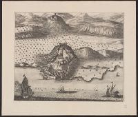
Call Number:
4035 1729
Container / Volume:
BRBL_00234
Image Count:
1
Resource Type:
Maps, Atlases & Globes
Description:
Relief shown pictorially. and Stamp: Karpinski-von Wieser Map Collection. "73"--Manuscript note in unidentified hand.
Subject (Geographic):
Trento (Italy : Province)--Maps--Early works to 1800
Subject (Name):
Aa, Pieter van der, 1659-1733
Found in:
Beinecke Rare Book and Manuscript Library > Évêché de Trente.
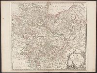
Creator:
Call Number:
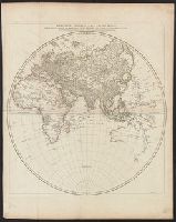
13 1761
Container / Volume:
BRBL_00011
Image Count:
1
Resource Type:
Maps, Atlases & Globes
Description:
"Sous le privilége d'Académie Chés l'Autr. aux Galeries du Louvre.", Relief shown pictorially., and Watermark.
Subject (Geographic):
Eastern Hemisphere--Maps--Early works to 1800
Found in:
Beinecke Rare Book and Manuscript Library > Heḿisphère oriental ou de l'ancien monde : publié sous les auspices de Monseigneur Louis Philippe duc d'Orléans, prémier prince du sang / par le Sr. d'Anville, de l'Académie Royales des Belles-Lettres, et de celles des sc̨iences de Pétersbourg ...
Branch:v1.64.0 ,Deployed:2024-09-11T10:25:25-04:00