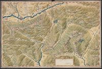
"This plat was drawne out in a paper Plat formerly made by me John Oliver for the Town of Dorchester and now by order it is drawn into parchment, April: 1661 by me Joshua Fisher." and Color. Pen and ink drawing.
Subject (Geographic):
Dorchester (Boston, Mass.)--Maps--Early works to 1800
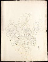
"Copia de esto plano se remitio á la Conte en 28 de Febrero de 1777 con carta no. 320. Doctor Julian Viso." and Manuscript map. Lakes, rivers, and swamps handtinted in green; limits of Dutch, French and Portuguese claims shown by red and dotted line, roughly paralleling the seacoast an the north bank of the Amazon as far as Fuerte Sn. Joseph de los Marivitanas; inside this line various European possessions indicated by lines of color as follows: Dutch, brown: French, yellow: Portuguese, green. Settlements shown by red dots. South at top.
Coordinates not present on map and are approximated., Manuscript number on verso: 2170., and With key in lower right corner, possibly for population of towns and cities.
"Indentured made ... between John Baillie late of Lovell Hill ... in the County of Berks ... and James George Scott ... 1823. and 1. 1st schedule, 2nd schedule, 2. Description of meadow land, 3. The new plan, 4. The Indenture.