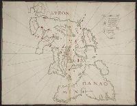
Color: Pen and ink drawing. and The map can only be definitely dated between the travels of Henry Middleton in 1608 and James Bruce in 1769. It is probably from around the 1690's or earlier because of the activity of the British East India Co. in this area at that time.
Subject (Geographic):
Jiddah (Saudi Arabia)--Maps, Manuscript--Early works to 1800
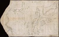
Color: pen and ink with green and blue shading., In the corner there is a table of the Florida and Cuban cays with their locations on the map. On the Island of Jamaica is marked Pta. Portland, presumably named after the Earl of Portland, councillor for trade and navigation, who died in 1663, or his son, who was killed fighting the Dutch in the battle off the Texel in 1665., On Jamaica the name "Kiniston" (Kingston) has been added early on, presumably about 1695, soon after its foundation, and in Hayti the name St. Luiz at a later period., and Spanish manuscript portolan chart on vellum. Unsigned and undated.
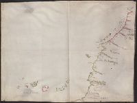
Carta Esferica que comprende las costas del Seno Mexicano construida de ordes del Rey en el deposito hidrografico de marina.
Description:
Backed with paper., Imperfect: mutilated along folds., Possibly copied from a Spanish chart "Carta Esferica que comprende las costas del Seno Mexicano construida de ordes del Rey en el deposito hidrografico de marina.", and Relief shown by hachures; depth by soundings.
Subject (Geographic):
Mexico, Gulf of--Maps.
Subject (Topic):
Coasts--Mexico--Maps. and Nautical charts--Mexico, Gulf of.
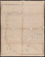
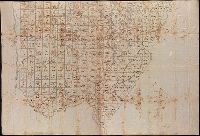
Coordinates not present on map and are approximated., Imperfect: mutilated., Relief shown by hachures., Shows government surveys with landowner and property boundaries drawn in., and Title devised by cataloger.