Skip to search
Skip to main content
Skip to first result
Search
You Searched For
Genre
Manuscript maps
Resource Type
Maps, Atlases & Globes
New Search
Search Results
Published / Created:
1832
Call Number:
462 1832
Container / Volume:
BRBL_00706
Image Count:
2
Resource Type:
Maps, Atlases & Globes
Description:
Color: beige with yellow and green detail.
Subject (Geographic):
Montenegro--Maps, Manuscript
Found in:
Beinecke Rare Book and Manuscript Library > Carte du pays de Montenegro dressé par Mr. Tverdiglebov l'Mayor au service de Russie en 1832.
Call Number:
BrSides Folio 2019 53
Image Count:
1
Resource Type:
Maps, Atlases & Globes
Alternative Title:
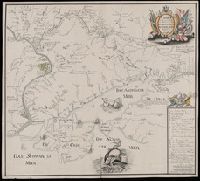
Karte der Kriegsoperation am Don und Dnepr
Description:
Includes map key to principal places., Relief shown pictorially., and Title from hand colored cartouche in upper right corner of sheet.
Subject (Geographic):
Russia--Maps--Early works to 1800.
Found in:
Beinecke Rare Book and Manuscript Library > Charte der Krieges operation am Donn und Dniper ihro Russisch Kayserl. Maist. glorieusen Armeen, 1736.
Published / Created:
[between 1750 and 1800?]
Call Number:
BrSides Double Folio 2019 78
Image Count:
1
Resource Type:
Maps, Atlases & Globes
Alternative Title:
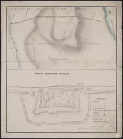
Chertezhʺ Perekopskoĭ kri︠e︡posti, Чертеж Перекопской крепости, Чертежъ Перекопской крѣпости, and Чертежъ Перекопской линий.
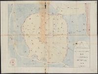
Description:
Stamp of the [Königliches] Kartographisches Institut, Berlin. Manuscript annotations on verso: "Die Linie von Perekop", "Perekopskoi krepost".
Subject (Geographic):
Crimea (Ukraine)--Maps--Early works to 1800.
Subject (Name):
Königliches Kartographisches Institut (Berlin) Stamp.
Subject (Topic):
Fortification--Ukraine--Crimea--Maps--Early works to 1800.
Found in:
Beinecke Rare Book and Manuscript Library > Chertezhʺ Perekopskoĭ liniĭ.
Published / Created:
[1681?]
Call Number:
BrSides Folio 2019 60
Image Count:
1
Resource Type:
Maps, Atlases & Globes
Alternative Title:
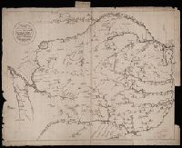
Чертезъ украинским и черкаскимъ городамъ от Москвы до Киева, и въ крымскую землу, дороги болшие, красные, черние, малшие.
Description:
Relief shown pictorially. and Stamp: Koenigl. Kartograph. Institut, Berlin. On verso in manuscript: "Mappa Expeditionis Moscovitica Duce Galicin Aõ 1681". Piece of paper with shelf mark attached at upper edge: "Cl. N. 16 [undeciphered].
Subject (Geographic):
Kiev (Ukraine : Oblast)--Maps--Early works to 1800.
Subject (Name):
Königliches Kartographisches Institut (Berlin) Stamp.
Found in:
Beinecke Rare Book and Manuscript Library > Chertezʺ ukrainskim i cherkaskimʺ gorodamʺ ot Moskvy do Kieva, i vʺ krymskui︠u︡ zemlu, dorogi bolshie, krasnye, chernie, malshie.
Published / Created:
1595
Call Number:
434 K83 1595
Container / Volume:
BRBL_00706
Image Count:
1
Resource Type:
Maps, Atlases & Globes
Description:
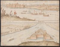
Color: Light blue and brown. and Two views of Komarno.
Subject (Geographic):
Komarno Czech Republic--Maps, Manuscript--Early works to 1800
Found in:
Beinecke Rare Book and Manuscript Library > Comorra [Komarno, Czechoslovakia]. Communicavit G. Houf [nagel].
Creator:
Published / Created:
1861
Call Number:
BrSides Folio 2018 140
Image Count:
1
Resource Type:
Maps, Atlases & Globes
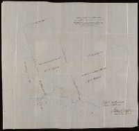
Description:
Coordinates not present on map and are approximated., From the Richard H. Rickard Papers., and North oriented towards the left.
Publisher:
Department of Crown Lands,
Subject (Name):
Montreal Mining Company., Ontario. Department of Crown Lands., and Rickard, Richard H.,---1885--Ownership.
Subject (Topic):
Mines and mineral resources--Ontario.
Found in:
Beinecke Rare Book and Manuscript Library > Copy of part of P.L.S. Salter's plan shewing mineral locations at and near Mamainse with a projection shewing Montreal Mining Company's location / Andrew Russell, Assistant Commissioner.
Published / Created:
[1780?]
Call Number:
40 P28 1780B
Container / Volume:
BRBL_00705
Image Count:
1
Resource Type:
Maps, Atlases & Globes
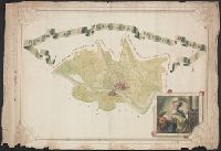
Description:
Color: various shades of green with some yellow detail. and Notes: Drawing in lower right hand corner possibly depicting Judith and Holofernes.
Subject (Geographic):
Italy--Maps, Manuscript--Early works to 1800
Found in:
Beinecke Rare Book and Manuscript Library > Del e Gazione Prima del Principato di Pavia.
Published / Created:
[1780?]
Call Number:
40 C862 1780
Container / Volume:
BRBL_00705
Image Count:
1
Resource Type:
Maps, Atlases & Globes
Description:
Color: light blue, pale yellow and rose.
Subject (Geographic):
Italy--Maps, Manuscript--Early works to 1800
Found in:
Beinecke Rare Book and Manuscript Library > Descrittíone del Territorio Cremasco con Confíní.
Published / Created:
[1720]
Call Number:
3748 1720
Container / Volume:
BRBL_00703
Image Count:
1
Resource Type:
Maps, Atlases & Globes
Description:
Color: Green and some blue.
Subject (Geographic):
Solothurn (Switzerland)--Maps, Manuscript--Early works to 1800
Found in:
Beinecke Rare Book and Manuscript Library > Die Orthographische und Ichnographische Vorstellung der neüen Landstrassen so durch die Solloturnerische Landschafft, vom Schloss Falckenstein durch das Thal biss an Mimlisweil ... [Soloturn to Basel].
Published / Created:
[between 1840 and 1849?]
Call Number:
BrSides Elephant Folio 2018 33
Image Count:
1
Resource Type:
Maps, Atlases & Globes
Description:
Backed with paper., Coordinates not present on map and are approximated., Imperfect: chipped, with some loss of text., Manuscript number on recto: 608., and Manuscript numbers on verso: 2170.
Subject (Geographic):
Udine (Italy : Province)--Maps.
Found in:
Beinecke Rare Book and Manuscript Library > Dipartimento del Passariano.
Branch:v1.61.6 ,Deployed:2024-06-12T09:55:36-04:00