Gouwen, Gilliam van der, engraver Visscher, Nicolaes, 1649-1702, cartographer
Call Number:
36 1706
Container / Volume:
BRBL_00117
Image Count:
1
Resource Type:
Maps, Atlases & Globes
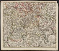
Description:
Borders are hand colored; larger cites are illustrated and colored red., Decorative title cartouche., Relief shown pictorially., Shows towns, rivers, and cities., and With reference grid.
Subject (Geographic):
Rhineland-Palatinate (Germany)--Maps--Early works to 1800
Relief shown pictorially. and Watermark. Manuscript number in right corner: 50. From the Karpinski-von Wieser Map Collection.
Publisher:
[Johann Baptist Homann]
Subject (Geographic):
Cologne (Electorate)--Maps--Early works to 1800., Jülich-Berg--Maps--Early works to 1800., and North Rhine-Westphalia (Germany)--Maps--Early works to 1800.
Subject (Name):
Catholic Church.--Archdiocese of Cologne (Germany)--Maps--Early works to 1800
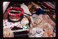
The description of this slide reflects the way that Erdoes organized 35mm slides. Erdoes arranged his slides in labeled containers that were sub-divided into labeled sections. The title for this image has been transcribed from its sub-section label; images of other slides from the same sub-section share the container title. The date listed here reflects a span of known dates associated the sub-section. In some cases, titles have been expanded to note particular individuals who appear frequently and who were identified by Erdoes in captions. Individual slide captions have not been transcribed or captured during digitization.
The description of this slide reflects the way that Erdoes organized 35mm slides. Erdoes arranged his slides in labeled containers that were sub-divided into labeled sections. The title for this image has been transcribed from its sub-section label; images of other slides from the same sub-section share the container title. The date listed here reflects a span of known dates associated the sub-section. In some cases, titles have been expanded to note particular individuals who appear frequently and who were identified by Erdoes in captions. Individual slide captions have not been transcribed or captured during digitization.
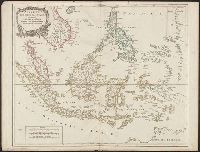
Covers present-day Indonesia, the Philippines, Malayan peninsula, Indo-Chinese peninsula, and north-west coast of Australia., From: Atlas universel / par m. Robert geographe et Robert de Vaugondy son fils. Paris, 1757-[1786]., Includes inset map., and Inset: Isl
Publisher:
[publisher not identified],
Subject (Geographic):
Asia--East Indies, Australia--Maps--Early works to 1800., East Indies--Maps--Early works to 1800., Mariana Islands--Maps--Early works to 1800., and Southeast Asia--Maps--Early works to 1800.
Subject (Name):
Haye, G. de la, engraver. and Robert de Vaugondy, Gilles, 1688-1766. Atlas universel.
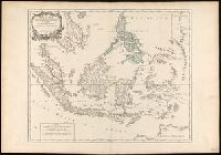
"Archipel des Indes" stamped twice on verso., Appeared in: Gilles and Didier Robert de Vaugondy, "Atlas Universel", 1753-1757 [or later]., Covers present-day Indonesia, the Philippines, Malayan peninsula, Indo-Chinese peninsula, and north-west coast of Australia., Includes inset map., Inset: Isles Marianes des Larons., Relief shown pictorially., and Watermarks.
Publisher:
[publisher not identified],
Subject (Geographic):
Southeast Asia--Maps--Early works to 1800.
Subject (Name):
Haye, G. de la, engraver., Robert de Vaugondy, Didier, 1723-1786. Atlas Universel., and Robert de Vaugondy, Gilles, 1688-1766. Atlas universel.
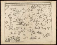
Archipelagi meridionalis, seu Cycladvm Insularum accurata delineatio
Description:
Includes three bar scales., Manuscript number in upper left corner: 33., Relief shown pictorially., and Verso blank.
Publisher:
[Jan Jansson],
Subject (Geographic):
Aegean Islands (Greece and Turkey)--Maps--Early works to 1800., Cyclades (Greece)--Maps--Early works to 1800., Dodecanese Islands (Greece)--Maps--Early works to 1800., and Sporades (Greece)--Maps--Early works to 1800.