Skip to search
Skip to main content
Skip to first result
Search
You Searched For
Extent of Digitization
Completely digitized
Resource Type
Maps, Atlases & Globes
Creator
United States. Office of Strategic Services. Research and Analysis Branch
New Search
Search Results
Creator:
Published / Created:
[1945?]
Call Number:
11hd 1945K-18
Container / Volume:
BRBL_00010ZG
Image Count:
1
Resource Type:
Maps, Atlases & Globes
Description:
"No. 6131 R&A, OSS, 1 February 1945."
Publisher:
Reproduction Branch, OSS,
Subject (Geographic):
Europe--Maps
Subject (Topic):
World War, 1939-1945--Campaigns--Western Front--Historical geography--Maps
Found in:
Beinecke Rare Book and Manuscript Library > The European fronts [cartographic material] : week ending 30 January.
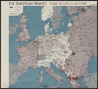
Creator:
Published / Created:
[1944?]
Call Number:
11hd 1945K-34
Container / Volume:
BRBL_00010ZG
Image Count:
1
Resource Type:
Maps, Atlases & Globes
Description:
"No. 5418--R&A, OSS, 2 November 1944."
Publisher:
Reproduction Branch, OSS,
Subject (Geographic):
Europe--Maps
Subject (Topic):
World War, 1939-1945--Campaigns--Western Front--Historical geography--Maps
Found in:
Beinecke Rare Book and Manuscript Library > The European fronts [cartographic material] : week ending 31 October.
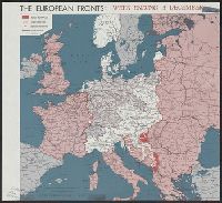
Creator:
Published / Created:
[1944?]
Call Number:
11hd 1945K-28
Container / Volume:
BRBL_00010ZG
Image Count:
1
Resource Type:
Maps, Atlases & Globes
Description:
"No. 5826--R&A, OSS, 7 December 1944."
Publisher:
Reproduction Branch, OSS,
Subject (Geographic):
Europe--Maps
Subject (Topic):
World War, 1939-1945--Campaigns--Western Front--Historical geography--Maps
Found in:
Beinecke Rare Book and Manuscript Library > The European fronts [cartographic material] : week ending 5 December.
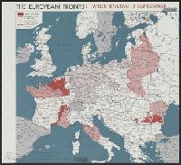
Creator:
Published / Created:
[1944?]
Call Number:
11hd 1945K-30
Container / Volume:
BRBL_00010ZG
Image Count:
1
Resource Type:
Maps, Atlases & Globes
Description:
"No. 5322--R&A, OSS, 7 September 1944."
Publisher:
Reproduction Branch, OSS,
Subject (Geographic):
Europe--Maps
Subject (Topic):
World War, 1939-1945--Campaigns--Western Front--Historical geography--Maps
Found in:
Beinecke Rare Book and Manuscript Library > The European fronts [cartographic material] : week ending 5 September.
Creator:
Published / Created:
[1945?]
Call Number:
11hd 1945K-10
Container / Volume:
BRBL_00010ZG
Image Count:
1
Resource Type:
Maps, Atlases & Globes
Description:
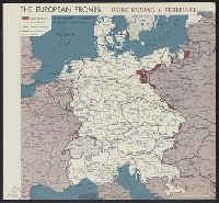
"No. 6132 R&A, OSS, 8 February 1945."
Publisher:
Reproduction Branch, OSS,
Subject (Geographic):
Europe--Maps
Subject (Topic):
World War, 1939-1945--Campaigns--Western Front--Historical geography--Maps
Found in:
Beinecke Rare Book and Manuscript Library > The European fronts [cartographic material] : week ending 6 February.
Creator:
Published / Created:
[1945?]
Call Number:
11hd 1945K-5
Container / Volume:
BRBL_00010ZG
Image Count:
1
Resource Type:
Maps, Atlases & Globes
Description:
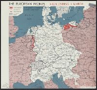
"No. 6241 R&A, OSS, 8 March 1945."
Publisher:
Reproduction Branch, OSS,
Subject (Geographic):
Europe--Maps
Subject (Topic):
World War, 1939-1945--Campaigns--Western Front--Historical geography--Maps
Found in:
Beinecke Rare Book and Manuscript Library > The European fronts [cartographic material] : week ending 6 March.
Creator:
Published / Created:
[1944?]
Call Number:
11hd 1945K-16
Container / Volume:
BRBL_00010ZG
Image Count:
1
Resource Type:
Maps, Atlases & Globes
Description:
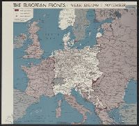
"No. 5521--R&A, OSS, 9 November 1944."
Publisher:
Reproduction Branch, OSS,
Subject (Geographic):
Europe--Maps
Subject (Topic):
World War, 1939-1945--Campaigns--Western Front--Historical geography--Maps
Found in:
Beinecke Rare Book and Manuscript Library > The European fronts [cartographic material] : week ending 7 November.
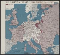
Creator:
Published / Created:
1945
Call Number:
11hd 1945K-21
Container / Volume:
BRBL_00010ZG
Image Count:
1
Resource Type:
Maps, Atlases & Globes
Description:
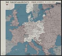
"11 January 1945.", "No. 5952.", "Restricted.", and Shows allied advances, allied operations, German operations, 1937 boundaries, and railroads.
Publisher:
Lithographed in the Reproduction Branch, OSS,
Subject (Geographic):
Europe--Maps
Subject (Topic):
World War, 1939-1945--Campaigns--Western Front--Historical geography--Maps
Found in:
Beinecke Rare Book and Manuscript Library > The European fronts [cartographic material] : week ending 9 January / R & A, OSS.
Creator:
Published / Created:
1944
Call Number:
42ed K66 1944
Container / Volume:
BRBL_00245
Image Count:
1
Resource Type:
Maps, Atlases & Globes
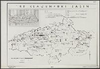
Description:
"From: Plebiscites since the World War, 1933, p. 167. By Sara [sic] Wambaugh.", "No. A-5378--R & A, OSS.", Inset map shows Yugoslav and German areas, and areas largely Germanized since 1851., and Shows boundaries of districts, communes and zones, and number of G
Publisher:
Reproduction Branch, OSS,
Subject (Geographic):
Carinthia (Austria)--Languages--Maps, Carinthia (Austria)--Maps, Carinthia (Austria)--Population--Maps, Slovenia--Languages--Maps, Slovenia--Maps, and Slovenia--Population--Maps
Subject (Name):
United States. Office of Strategic Services. Reproduction Branch and Wambaugh, Sarah, 1882-1955
Subject (Topic):
Slovenes--Austria--Carinthia--Maps and Yugoslavs--Austria--Carinthia--Maps
Found in:
Beinecke Rare Book and Manuscript Library > The Klagenfurt Basin [cartographic material].
Creator:
Published / Created:
1943
Call Number:
46 l769 1930
Container / Volume:
BRBL_00259
Image Count:
1
Resource Type:
Maps, Atlases & Globes
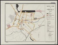
Description:
Indexes hotels and points of interest. and Map no. 2803.
Publisher:
R & A, OSS,
Subject (Geographic):
Ljubljana (Slovenia)--Maps
Found in:
Beinecke Rare Book and Manuscript Library > Town plan of Ljubljana [cartographic material] : date prior to 1930.
Branch:v1.62.0 ,Deployed:2024-06-26T09:56:55-04:00