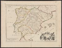
"Dedié au Roy par son très humble, très obeissant, très fidele suget et serviteur. Hubert Iaillot, géographe de Sa Majeste.", Appears in Jaillot's Atlas françois., Boundaries hand colored., Includes eight bar scales., Relief shown pictorially., and Sheet mea
Subject (Geographic):
North America--Maps--Early works to 1800
Subject (Name):
Albany Institute Stamp, Cordier, Louis, -1711, engraver, and Jaillot, Alexis Hubert, 1632?-1712. Atlas françois
"Cum priuilegio Regio.", Bar scale given in "scala milliarum.", Hand colored borders., Ms. no. on recto and verso: 155. Stamp on vers, and Relief shown pictorially.
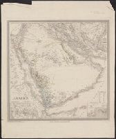
Appears in Allgemeiner Hand-Atlas der Erde und des Himmels nach den best, Prime meridian: Ferro., Relief shown by hachures and spot heights., and Shows physical and ethnographic features, regional and political boundaries, caravan trails, and tribal affiliation.
Subject (Geographic):
Aden (Yemen)--Maps, Arabian Peninsula--Maps, Mecca (Saudi Arabia)--Maps, and Sinai (Egypt)--Maps
Gouwen, Gilliam van der, engraver Visscher, Nicolaes, 1649-1702, cartographer
Call Number:
36 1706
Container / Volume:
BRBL_00117
Image Count:
1
Resource Type:
Maps, Atlases & Globes
Description:
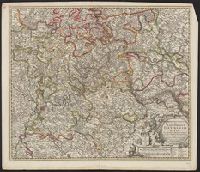
Borders are hand colored; larger cites are illustrated and colored red., Decorative title cartouche., Relief shown pictorially., Shows towns, rivers, and cities., and With reference grid.
Subject (Geographic):
Rhineland-Palatinate (Germany)--Maps--Early works to 1800
"2764"., Compiled chiefly from the Surveys by Captains Flinders, Blackwood, Stanley, Yule & Denham 1802-60, with additions from various surveys to 1885., Includes large corrections to Mar. 1896, and small corrections to "IX.11.", Prime meridian: Greenwich., and R
Subject (Geographic):
Coral Sea--Maps and Great Barrier Reef (Qld.)--Maps
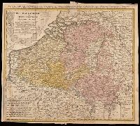
Belgium Catholicum seu decem provinciae Germaniae inferioris and Carte des Pais Bas catholiques où des X provinces de l'Allegmagne inférieure, etc. dessinée au juste selon les exactes observations astronomiques et opérations géometriques des Messur. Cass
Description:
"Avec privil. Imperial" above neat line., Includes 8 bar scales., Includes coats-of-arms of ten provinces., Relief shown pictorially., and Watermark. Manuscript number in upper right corner: 262[?]. From the Karpinski-von Wieser Map Collection.
Publisher:
Edentibus Homannianis heredib.,
Subject (Geographic):
Belgium--Maps--Early works to 1800. and Luxembourg--Maps--Early works to 1800.
Subject (Name):
Cassini, César-François, 1714-1784, Homann Erben (Firm), and Snellius, Willebrord, 1580-1626
Tardieu, P. F. (Pierre François), 1757-1822, author
Call Number:
451 1770
Container / Volume:
BRBL_00258
Image Count:
1
Resource Type:
Maps, Atlases & Globes
Description:
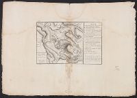
"A. Pl. 34.", Bar scales given in "Echelle de 600 Sagenes" and "Echelle de 600 Toises.", Coordinates not present on map and are approximated, From Nicolas-Gabriel Clerc's Histoire physique, morale, civile et politique de la Russie moderne., and Includes legend to
Subject (Geographic):
Bender (Moldova)--Maps--Early works to 1800
Subject (Name):
Clerc, Nicolas-Gabriel, 1726-1798. Histoire physique, morale, civile et politique de la Russie moderne