Frezier, Amedee Francois, 1682-1773 Robert de Vaugondy, Gilles, 1688-1766, creator
Published / Created:
avec privilege 1749
Call Number:
2003 Folio 85
Image Count:
1
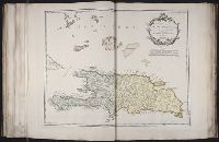
Description:
BEIN 2003 Folio 85: No. 32 of 45 maps bound together with binder's spine title: Atlas of America; ms. table of contents. Bookplate: Robinson. Bookplate of Paul Mellon., Hand colored., par le Sr. Robert geographe ordin. du roi., and Scale [ca. 1:1,370,000].
Publisher:
Robert de Vaugondy
Subject (Geographic):
Dominican Republic -- Maps -- Early works to 1800 and Haiti -- Maps -- Early works to 1800
Bellin, Jacques Nicolas, 1703-1772, creator France, Depot des cartes et plans de la marine Rameau, P.
Published / Created:
1763
Call Number:
2003 Folio 85
Image Count:
1
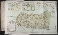
Description:
BEIN 2003 Folio 85: No. 40 of 45 maps bound together with binder's spine title: Atlas of America; ms. table of contents. Bookplate: Robinson. Bookplate of Paul Mellon., dressee au Depost des cartes et plans de la marine ; pour le service des vaisseaux du roy ; par ordre de M. le Duc de Choiseul, ministre de la guerre et de la marine ; par le Sr. Bellin, ingenieur de la marine., Hand colored., Insets: Plan du port du Carenage; Plan du cul de sac des Roseaux [with inset: Plan du cul de sac des Roseaux, reduit sur l'echelle du port du Carenage pour comparer leur grandeur]; Mouillages du Grand Islet et du Choc., P.A. Rameau fecit. 1763., Relief shown pictorially., and Scale [ca. 1:115,000].
Bellin, Jacques Nicolas, 1703-1772, creator France, DeÌpot des cartes et plans de la marine
Published / Created:
1760
Call Number:
2003 Folio 85
Image Count:
1
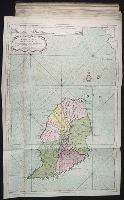
Description:
BEIN 2003 Folio 85: No. 41 of 45 maps bound together with binder's spine title: Atlas of America; ms. table of contents. Bookplate: Robinson. Bookplate of Paul Mellon., dressee au Depost des cartes et plans de la marine ; pour le service des vaisseaux du roy ; par ordre de M. Berryer, ministre et secretaire d'Etat aiant le Departemente de marine ; par le S. Bellin, ingenieur de la marine, du Depost des plans &c., Hand colored., Relief shown pictorially., and Scale [ca. 1:62,000].
Bellin, Jacques Nicolas, 1703-1772, creator Croisey, P. France, Depot des cartes et plans de la marine
Published / Created:
1763
Call Number:
2003 Folio 85
Image Count:
1
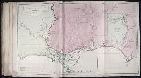
Description:
BEIN 2003 Folio 85: No. 45 of 45 maps bound together with binder's spine title: Atlas of America; ms. table of contents. Bookplate: Robinson. Bookplate of Paul Mellon., Croisey sculpsit., dressee au Depost des cartes et plans de la marine ; pour le service des vaisseaux du roy ; par ordre de M. le Duc de Choiseul, ministre de la guerre at de la marine ; par le S. Bellin., Hand colored., Inset: Isle de Cayenne dans la Guyane., Relief shown pictorially. Depths shown by soundings., and Scale [ca. 1:1,000,000].
Publisher:
Depost des cartes et plans de la marine
Subject (Geographic):
Cayenne (French Guiana) -- Maps -- Early works to 1800 and French Guiana -- Maps -- Early works to 1800
Subject (Topic):
Nautical charts -- French Guiana -- Early works to 1800
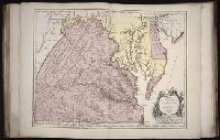
BEIN 2003 Folio 85: No. 25 of 45 maps bound together with binder's spine title: Atlas of America; ms. table of contents. Bookplate: Robinson. Bookplate of Paul Mellon., Hand colored., par le sr. d'Anville ; dresse en Mai 1732 ; publiee en 1752, and Scale [ca. 1:940,000].
Bellin, Jacques Nicolas, 1703-1772, creator France, Depot des cartes et plans de la marine
Published / Created:
1755?
Call Number:
2003 Folio 85
Image Count:
1
Description:
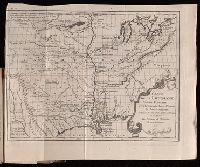
Available also through the Library of Congress Web site as a raster image., BEIN 2003 Folio 85: No. 23 of 45 maps bound together with binder's spine title: Atlas of America; ms. table of contents. Bookplate: Robinson. Bookplate of Paul Mellon., Covers the area from Quebec to the Gulf of Mexico and west of Santa Fe, N.M., Hand colored., LC Maps of North America, 1750-1789,, Longitude du meridien de l'ile de Fer., Par le Sr. Bellin, ingr. ordre. de la marine, 1750., Relief shown pictorially., Scale [ca. 1:5,800,000]., Shows cities and towns, forts, some trails, and Indian villages and tribal territory., and Sur de nouvelles observations on a corrige les lacs, et leurs environs, 1755.
Subject (Geographic):
Louisiana -- Maps -- Early works to 1800 and North America -- Maps -- Early works to 1800
Fry, Joshua, 1700 (ca.)-1754 Haussard, Elisabeth. Jefferson, Peter, 1708-1757 Robert de Vaugondy, Gilles, 1688-1766 Robert de Vaugondy, Gilles, 1688-1766, creator
Published / Created:
1755
Call Number:
2003 Folio 85
Image Count:
1
Description:
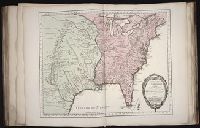
BEIN 2003 Folio 85: No. 22 of 45 maps bound together with binder's spine title: Atlas of America; ms. table of contents. Bookplate: Robinson. Bookplate of Paul Mellon., dressee sur la grande carte angloise de Mrs. Josue Fry et Pierre Jefferson ; par le Sr. Robert de Vaugondy, geographe ordinaire du Roi., Grave E. Haussard., Hand colored., Relief shown pictorially., Scale [ca. 1:870,000], and Shows Virginia, Maryland, and De La War counties.
Subject (Geographic):
Maryland -- Maps -- 1755, Maryland -- Maps -- Early works to 1800, Middle Atlantic States -- Maps -- 1755, Middle Atlantic States -- Maps -- Early works to 1800, Virginia -- Maps -- 1755, and Virginia -- Maps -- Early works to 1800