Lucas, Fielding, 1781-1854 Warr, John, b. ca. 1798 Warr, William W
Published / Created:
[1862], c1852
Call Number:
21cea 1862
Image Count:
1
Resource Type:
Maps, Atlases & Globes
Alternative Title:
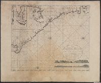
Chesapeake and Delaware Bays.
Description:
"Drawn by F. Lucas, Jr.", "Engraved by John and William W. Warr, Philadelphia.", "Sold by Lucas Brothers.", Depths shown by soundings and shading., and Includes views: View of the coast from Indian River to Cape Henlopen [Del.] -- Windmill Point [Va.] -- Smiths P
Publisher:
Fielding Lucas,
Subject (Geographic):
Chesapeake Bay Region (Md. and Va.)--Maps and Delaware Bay Region (Del. and N.J.)--Maps
Subject (Topic):
Coasts--Delaware--Maps, Coasts--Maryland--Maps, Coasts--New Jersey--Maps, and Coasts--Virginia--Maps
Great Britain. Hydrographic Dept Stokes, J. Lort (John Lort), 1811-1885
Published / Created:
Aug. 16th. 1852 [i.e. 1865]
Call Number:
26cea 1851B
Container / Volume:
BRBL_00023
Image Count:
1
Resource Type:
Maps, Atlases & Globes
Description:
"Corrections to ... Mar. 65.", Chart "2142.", and Chart of coast from Barriga Point to Jervis Bay with relief shown by hachures, bathymetric soundings and spot heights.
Publisher:
Published according to Act of Parliament at the Hydrographic Office of The Admiralty : and Sold by J.D. Potter Agent for the Admiralty charts 31 Poultry,
"2144"., "Corrections Sept. 1862.", and Chart of coast from Broken Bay to Sugarloaf Point with relief shown by hachures, bathymetric soundings and spot heights.
Publisher:
Published according to Act of Parliament at the Hydrographic Office of The Admiralty : and Sold by J.D. Potter Agent for the Admiralty charts 31 Poultry,
Evans, F. J. (Frederick J.) Great Britain. Hydrographic Dept J. & C. Walker (Firm) Potter, J. D. (John D.) Washington Capt
Published / Created:
Decr. 12th 1860.
Call Number:
26cea 1860
Container / Volume:
BRBL_00023
Image Count:
1
Resource Type:
Maps, Atlases & Globes
Alternative Title:
Coral Sea and Great Barrier Reefs shewing the inner and outer routes to Torres Strait
Description:
"2764"., Imperfect: Mutilated with loss of tex, Nautical chart of the Great Barrier Reef and the Coral Sea showing routes to the Torres Strait. Relief is shown by hachures and spot heights. Depth shown by bathymetric soundings., and On verso: XXVIII.
Publisher:
Published at the Admiralty ... under the superintendence of Captn. Washington R.N., F.R.S. Hydrographer ; Sold by J.D. Potter, agent for the Admiralty charts, 31 Poultry and 11 King Street, Tower Hill,
Subject (Geographic):
Coral Sea--Maps and Great Barrier Reef (Qld.)--Maps
Faden, William, 1749-1836 Palmer, W. (William), 1739-1812 Roberts, Henry, Lieut
Published / Created:
1784
Call Number:
23 1784
Container / Volume:
BRBL_00019
Image Count:
1
Resource Type:
Maps, Atlases & Globes
Alternative Title:
Chart of the northwest coast of America and the northeast coast of Asia, explored in the years 1778 and 1779
Description:
Includes notes., Relief shown pictorially. Depths shown by soundings., and Sheet measures 53 x 80.5 cm.
Publisher:
Wm. Faden, geographer to the King, Charing Cross,
Subject (Geographic):
Bering Strait Region--Discovery and exploration--Maps--Early works to 1800, North America--Discovery and exploration--Maps--Early works to 1800, and Pacific Coast (North America)--Discovery and exploration--Maps--Early works to 1800
Subject (Name):
Cook, James,--1728-1779
Subject (Topic):
Discoveries in geography--Maps--Early works to 1800
Appears in J. van Keulen's De nieuwe groote lichtende zee-fakkel., Copy 2: Not colored., In bottom right: 7., Includes 2 coastal profiles, 2 insets, and rhumb lines., Oriented with north to the left., and Relief shown pictorially. Depths shown by soundings.
Publisher:
Gerard van Keulen, boek en zeekaart verkooper aen de Nieuwen Brugh,
Subject (Geographic):
Africa, Central--Maps--Early works to 1800 and Coasts--Africa, West--Maps--Early works to 1800
Subject (Name):
Keulen, Johannes van, fl. 1726-1753. Nieuwe groote lichtende zee-fakkel
Subject (Topic):
Nautical charts--Africa, Central--Early works to 1800