Red River, Sabine & Western Railway and Red River, Sabine and Western Railway
Description:
"I.[?] C. Terry, Chf. Eng.", Covers Texas and Louisiana, and parts of New Mexico, Indian Territory, Arkansas, Mississippi, and northern Mexico., From the Streeter collection., and Library's copy imperfect: Holes in center.
Publisher:
s.n.,
Subject (Name):
Red River, Sabine and Western Railway--Maps and Streeter, Thomas W.--(Thomas Winthrop),--1883-1965--Ownership
Subject (Topic):
Coal--Texas--Maps, Forests and forestry--Louisiana--Maps, Forests and forestry--Texas--Maps, Iron--Texas--Maps, Petroleum--Texas--Maps, Railroads--Louisiana--Maps, and Railroads--Texas--Maps
"Though the map ... has an 1840 date, it appears from a letter of J.H. Overton, United States Commissioner, dated Opelousas, Louisiana, August 10, 1841 ... and the reply of October 1, 1841 ... that the maps ... had not been forwarded at that time. However, they had been received by January 15, 1842 ..and that they were issued by March 17, 1842, is shown by the reprintings of them accompanying the President's message of that date"--Streeter, Bibliographof Texas, 1438., At head of title: A.2., From the Streeter collection., Relief shown by hachures., and Three parallel sections of 12 miles each.
Publisher:
s.n.,
Subject (Geographic):
Texas--Boundaries--United States--Maps and United States--Boundaries--Texas--Maps
Subject (Name):
Streeter, Thomas W.--(Thomas Winthrop),--1883-1965--Ownership
Part of the boundary between the United States and Texas, north of Sabine River from the 36th to the 72nd mile mound
Description:
"Though the map ... has an 1840 date, it appears from a letter of J.H. Overton, United States Commissioner, dated Opelousas, Louisiana, August 10, 1841 ... and the reply of October 1, 1841 ... that the maps ... had not been forwarded at that time. However, they had been received by January 15, 1842 ... and that they were issued by March 17, 1842, is shown by the reprintings of them accompanying the President's message of that date"--Streeter, T.W. Bibliography of Texas, 1438., At head of title: B.2., From the Streeter collection., Relief shown by hachures., and Three parallel sections of 12 miles each.
Publisher:
s.n.,
Subject (Geographic):
Texas--Boundaries--United States--Maps and United States--Boundaries--Texas--Maps
Subject (Name):
Streeter, Thomas W.--(Thomas Winthrop),--1883-1965--Ownership
"Though the map ... has an 1840 date, it appears from a letter of J.H. Overton, United States Commissioner, dated Opelousas, Louisiana, August 10, 1841 ... and the reply of October 1, 1841 ... that the maps ... had not been forwarded at that time. However, they had been received by January 15, 1842 ... and that they were issued by March 17, 1842, is shown by the reprintings of them accompanying the President's message of that date"--Streeter, T.W. Bibliography of Texas, 1438., At head of title: C.2., From the Streeter collection., and Three parallel sections, two of twelve miles each and one of 10 miles.
Publisher:
s.n.,
Subject (Geographic):
Texas--Boundaries--United States--Maps and United States--Boundaries--Texas--Maps
Subject (Name):
Streeter, Thomas W.--(Thomas Winthrop),--1883-1965--Ownership
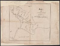
Survey of five leagues of land belonging to Wm P. Harris & others
Description:
"...in the 1837 [New Orleans] directory...P. Snell was listed, 'Canal near Bourbo, Library's copy imperfect: upper left corner missing., Oriented with north toward lower right., and Shows land tracts west of Galveston Bay and north of Clear Lake and Clear Creek.
Publisher:
s.n.,
Subject (Geographic):
Harris County (Tex.)--Maps
Subject (Name):
Harris, William P, Snell, P, and Streeter, Thomas W.--(Thomas Winthrop),--1883-1965--Ownership