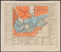
Above neat line at right: Tom VI. no. 21 pag: 90., Chatelain copy of Lahontan's 1703 map of Canada., Fr, Hand col. Mounted on linen. Sheet measures 43.8 x 51.8 cm. Cross Collection no. 190., and Map bordered by tables listing Indian nations and animals of Canada.
Publisher:
Henri Abraham Chatelain,
Subject (Geographic):
Canada--Maps--Early works to 1800 and Great Lakes (North America)--Maps--Early works to 1800
Subject (Name):
Chatelain, Henri Abraham. Atlas historique and Lahontan, Louis Armand de Lom d'Arce, baron de, 1666-1715?
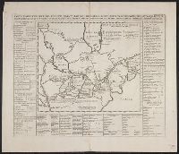
Chatelain copy of Lahontan's 1703 map of Canada., From Chatelain's Atlas historique ... Amsterdam : Chez François L'Honoré & Compagnie ..., [1719], Map bordered by tables listing Indian nations and animals of Canada., and Sheet measures 45.2 x 50.8
Publisher:
Henri Abraham Chatelain,
Subject (Geographic):
Canada--Maps--Early works to 1800 and Great Lakes (North America)--Maps--Early works to 1800
Subject (Name):
Chatelain, Henri Abraham. Atlas historique and Lahontan, Louis Armand de Lom d'Arce, baron de, 1666-1715?
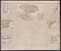
Above neat line at right: Tom VI. no. 21 pag: 90., Chatelain copy of Lahontan's 1703 map of Canada., From Chatelain's Atlas historique ... Amsterdam : Chez François L'Honoré & Compagnie ..., [1719], Map bordered by, and Sheet measures 45.2 x 52.9 cm.
Publisher:
Henri Abraham Chatelain,
Subject (Geographic):
Canada--Maps--Early works to 1800 and Great Lakes (North America)--Maps--Early works to 1800
Subject (Name):
Chatelain, Henri Abraham. Atlas historique and Lahontan, Louis Armand de Lom d'Arce, baron de, 1666-1715?
Carte de la Jamaique [with inset of Gulf of Mexico and Caribbean Area] -- Ile des Barbades -- Nouve, Mounted on linen. Sheet measures 44.6 x 53.3 cm. Cross Collection no. 153., Probably from Chatelain's Atlas historique, 1705-1720., and Relief shown pictorially.
Publisher:
Chez l'Honoré & Châtelain Libraires?,
Subject (Geographic):
Caribbean Area--Maps--Early works to 1800, Great Britain--Colonies--America--Maps--Early works to 1800, and North America--Maps--Early works to 1800
Bar scales given in "Milliaria Germanica communia" and "Milliaria Gallica communia"., Date inferred from C. Koeman's Atlantes Neerlandici, v. 3, p. 165 (Vis 10, map 7)., Prime meridian: Ferro., Relief shown pictorially., and Sheet measures 49.6 x 58.8
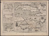
Ancillary maps: Insula Iamaica -- Ins. S. Ioannis -- Is. Margareta cum confinijis., Cuba Insula includes inset "Havana portus celeberimus totius indiae Occidentalis.", Latin text on verso; with caption title "Cuba, Hispaniola Iamai, and Relief shown pictorially.
Publisher:
Jodocus Hondius,
Subject (Geographic):
Cuba--Maps--Early works to 1800 and Hispaniola--Maps--Early works to 1800
Subject (Name):
Hondius, Jodocus, 1563-1612 and Mercator, Gerhard, 1512-1594. Atlas. French
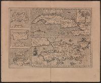
Cuba Insula includes inset "Havana portus celeberimus totius indiae Occidentalis.", French text on verso; with caption title "Les isles de la Cuba, Espaignole, Iamaique, de S. Iean et Margarite," paginated 701, 704, with signatures 8P., and Relief shown pictorially.
Publisher:
Hendrik Hondius,
Subject (Geographic):
Cuba--Maps--Early works to 1800 and Hispaniola--Maps--Early works to 1800
Subject (Name):
Hondius, Hendrik, 1597-1651 and Mercator, Gerhard, 1512-1594. Atlas. French
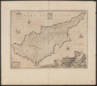
Bar scales given in "milliaria Italica" and "milliaria Germanica"., From Joan Blaeu's Atlas maior. Amstelaedami : ... Ioannis Blaeu, 1662., In Latin on verso; running title "Cyprus Insula," paginated 25-26, with signature I., Prime meridian: Ferro., and Relief sh
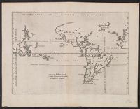
From Herrera y Tordesillas's Descripción de las Indias Occidentales ... Amstelodami : Apud M. Colinium, 1622., Map of the World from China, west to Spain showing the 'Merida, Relief shown pictorially., and Sheet measures 28.5 x 36.9 cm. Cross Collection no. 112.
Publisher:
Michiel Colijn,
Subject (Geographic):
World maps--Early works to 1800
Subject (Name):
Colijn, Michiel, Herrera y Tordesillas, Antonio de, d. 1625. Descripción de las Indias Occidentales. Latin, and Portugal.--Treaties, etc.--Spain--(1494 June 7)