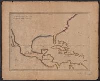
Appears in French eds. of Herrera y Tordesilla's Descripción de las Indias Occidentales published in Amsterdam., Sheet measures 28.7 x 35.2 cm. Cross Collection no. 227., and Shows coasts of the southern part of North America, Central America, northern coast of South America, and West Indies.
Publisher:
s.n. ,
Subject (Name):
Herrera y Tordesillas, Antonio de, d. 1625. Descripción de las Indias Occidentales. French
Subject (Topic):
Coasts--Central America--Maps--Early works to 1800, Coasts--North America--Maps--Early works to 1800, Coasts--South America--Maps--Early works to 1800, and Coasts--West Indies--Maps--Early works to 1800
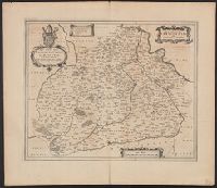
Description, situation and vue de la ville de Mexique
Description:
"Tom: VI. No. 28. Pag: 110.", Caption title., Carte du Mexique -- Environs du Lac de Mexique., From Chatelain's Atlas historique ... [v. 6, no. 28, p. 110] Amsterdam : Chez L'Honoré & Châtelain, 1718-21., and Includes ill. and text, "La Province de Mexique ... & plus de 100, mille Esclaves."
Publisher:
L'Honoré & Châtelain,
Subject (Geographic):
Mexico City (Mexico)--Maps--Early works to 1800 and Mexico--Maps--Early works to 1800
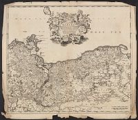
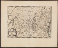
Bar scale given in "miglia sette.", Decorative cartouche., In Latin on verso, with running title "Ducatus Parma et Placentia," paginated 29, with signature 2A., Relief shown pictorially., and Stamp on verso: Karpinski-von Wieser Map Collection.
Publisher:
Blaeu,
Subject (Geographic):
Parma (Italy : Province)--Maps--Early works to 1800 and Piacenza (Italy : Province)--Maps--Early works to 1800
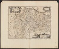
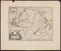
Imperfect: torn along folds and chipped at edges, with no loss of text. Sheet measures 54.0 x 61.9 cm., Prime meridian: Ferro., Relief shown pictorially., and Variant of Koeman, C. Atlantes Neerlandici, III, p. 215, map 99 (without privilege statement
Publisher:
Frederik de Wit?,
Subject (Geographic):
Pomerania (Poland and Germany)--Maps--Early works to 1800