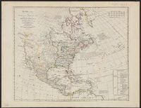
Date taken from description by Stevens and Tree in Tooley's Mapping of America, p. 81, item 56., Includes historical notes and table of "Methodical di, Prime meridian: Ferro., Relief shown pictorially., and Yale's copy stamped on verso: Yale, Horace Brown, 1900S.
Publisher:
Printed for the proprietor Carington Bowles,
Subject (Geographic):
North America--Maps--Early works to 1800
Subject (Name):
Bowles, Carington, 1724-1793 and Palairet, Jean, 1697-1774
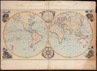
Hand coloured double hemispheric map of the world (Western hemisphere, or, the New World, and Eastern hemisphere, or, the Old World), with four decorative hand coloured vignettes representing Europe, Asia, America, and Africa., Includes an ornate compas rose and an elablorate title cartouche., Mounted on board., The map perpetuates some errors regarding the geography of the northwest coast of America., and Traces the voyages of some important explorers of the second half of the 18th century, including Cook's first voyage.
Publisher:
Printed for the Proprietor, Carington Bowles, No. 69, in St. Paul's Churchyard,
"The figures on the map refer to the pages in the guide where the train services are shewn.", Also shows steamship routes and distances., Includes inset of London region and copyright note., and Metropolitan London cab regulations, list of railroad stations in L
Publisher:
Henry Blacklock & Co. Ltd., Engravers and Lithographers,
Subject (Geographic):
British Isles--Maps
Subject (Topic):
Railroad stations--Great Britain--Maps, Railroads--Great Britain--Maps, Railroads--Ireland--Maps, and Steamboat lines--Great Britain--Maps