Skip to search
Skip to main content
Skip to first result
Search
You Searched For
Format
cartographic
Language
French
New Search
Search Results
Creator:
Published / Created:
1628]
Call Number:
655 1628
Container / Volume:
BRBL_00345
Image Count:
2
Resource Type:
Maps, Atlases & Globes
Alternative Title:
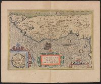
Gvineae nova descriptio
Description:
From the author's Gerardi Mercatoris atlas. 1628., Inset: I. S. Thomae., Map text in Latin. Text on verso in French., Relief shown pictorially., and Text on verso titled "Guinee, avec les isles de S. Thomas, du Prince, et d'Anobon," p. 637 and 640.
Publisher:
Sumptibus & typis aeneis Henrici Hondij,
Subject (Geographic):
Africa, West--Maps--Early works to 1800
Subject (Name):
Hondius, Hendrik, 1597-1651 and Mercator, Gerhard, 1512-1594. Gerardi Mercatoris Atlas
Found in:
Beinecke Rare Book and Manuscript Library > Guineae nova descriptio.
Creator:
Published / Created:
1743
Call Number:
655 1743
Container / Volume:
BRBL_00345
Image Count:
1
Resource Type:
Maps, Atlases & Globes
Alternative Title:
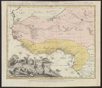
Guinea propria, nec non Nigritiæ vel Terræ Nigrovrm maxima pars, Guinee de meme que la plus grande partie du Pais des Negres, and Gvinee de meme que la plus grande partie du Pais des Negres
Description:
Covers West Africa from Gabon in the south to Niger, Mali, and Mauritania in the north., Has watermark., Includes indexed ill. depicting the dress, dwellings, and work of native Africans., Prime meridian: Ferro., and Relief shown pictorially.
Publisher:
Homannianorum Heredum,
Subject (Geographic):
Africa, West--Maps--Early works to 1800
Subject (Name):
Anville, Jean Baptiste Bourguignon d', 1697-1782 and Marchais, R. de
Found in:
Beinecke Rare Book and Manuscript Library > Gvinea propria, nec non Nigritiæ vel Terrae Nigrorvm maxima pars : geographis hodiernis dicta utraq[ue] Aethiopia inferior, & hujus quidem pars australis / ex delineationibus Anvillianis itineri guineensi D. de Marchais insertis secundum leges projectioni
Published / Created:
1659
Call Number:
11 1659
Container / Volume:
BRBL_00003
Image Count:
1
Resource Type:
Maps, Atlases & Globes
Description:
Preliminary record.
Publisher:
Sanson,
Subject (Geographic):
World--Maps--Early works to 1800
Found in:
Beinecke Rare Book and Manuscript Library > Harmonie ou Correspondance du globe avecq la sphere par les points, lignes, cerches, &c ... par le S. Sanson d'Abbeville ... Jean Somer Pruthenus, Sculpsit.
Creator:
Published / Created:
ca. 1751
Call Number:
1983 Folio 23
Collection Title:
[Atlas factice of 50 maps, primarily by Johann Baptist Homann and/or issued by the Homann Erben
Image Count:
1
Alternative Title:
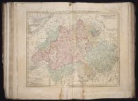
Helvetia tredecim statibus liberis, quos cantones vocant composita and Suisse, divisee en ses treze cantons, ses alliez et ses sujets
Publisher:
Luci publicae tradita ab Homannianis Heredibus
Subject (Geographic):
Switzerland --Maps --Early works to 1800
Collection Created:
[Nuremberg : Homann Erben, 1710-1786]
Found in:
Beinecke Rare Book and Manuscript Library > Helvetia tredecim statibvs liberis, quos cantones vocant composita: una cum foederatis & subjectis provinciis, ex probatissimis subsidiis
Creator:
Published / Created:
a. 1751
Call Number:
1973 Folio 30
Collection Title:
[Atlas factice of 32 maps and 1 distance table, produced by the Homann Erben firm]
Image Count:
2
Alternative Title:
Helvetia tredecim statibus liberis, quos cantones vocant composita and Suisse, divisee en ses treze cantons, ses alliez et ses sujets
Publisher:
Luci publicae tradita ab Homannianis Heredibus
Subject (Geographic):
Switzerland --Maps --Early works to 1800
Subject (Topic):
Atlases, German --Early works to 1800
Collection Created:
[Nuremberg : s.n., 1701-1760]
Found in:
Beinecke Rare Book and Manuscript Library > Helvetia tredecim statibvs liberis, qvos cantones vocant composita [cartographic material] : una cum foederatis & subjectis provinciis, ex probatissimis subsidiis / geographice delineata per Dm. Tobiam Mayerum, Professorem Matth., Goettingensem
Published / Created:
1762
Call Number:
19 1762
Container / Volume:
BRBL_00013
Image Count:
1
Resource Type:
Maps, Atlases & Globes
Description:
Preliminary record. and Routes of Navigators shown.
Subject (Geographic):
Antarctica--Maps--Early works to 1800
Found in:
Beinecke Rare Book and Manuscript Library > Hemisphere Meridional dressé en 1754 par M. Le Comte de Redern, Curateur ... Académie Royale des Sciences ... executé par ordre de l'Academie en 1762.
Published / Created:
1782
Call Number:
13 1782
Container / Volume:
BRBL_00011
Image Count:
1
Resource Type:
Maps, Atlases & Globes
Description:
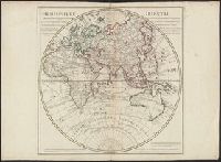
Showing routes of Captain Cook and other navigators.
Publisher:
Dezauche,
Subject (Geographic):
Eastern Hemisphere--Maps--Early works to 1800
Found in:
Beinecke Rare Book and Manuscript Library > Hemisphere Oriental ...
Published / Created:
1762
Call Number:
18 1762
Container / Volume:
BRBL_00012
Image Count:
1
Resource Type:
Maps, Atlases & Globes
Description:
Contemporary notation in ink, verso: Nördliche Halb Kugel and Routes of Navigators shown.
Subject (Geographic):
Arctic Regions--Maps--Early works to 1800
Found in:
Beinecke Rare Book and Manuscript Library > Hemisphere Septentrional dressé en 1754 par Mr. le Comte de Redern, Curateur de l'Académie des Sciences ... par ordre de l'Académie.
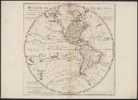
Creator:
Published / Created:
[1782]
Call Number:
70 1782
Container / Volume:
BRBL_00356
Image Count:
1
Resource Type:
Maps, Atlases & Globes
Description:
In lower right: Ph. Buache, P.G.d.R, d l'A.R.d.S. Gendre de l'auteur. Avec privilège du Roi., Library's copy stamped on backing: Yale University Library, Karpinski-Von Wieser Map Collection., and Relief shown pictorially.
Publisher:
Dezauche,
Subject (Geographic):
America--Discovery and exploration--Maps and Western Hemisphere--Maps
Subject (Name):
Buache, Philippe, 1700-1773, Cook, James--(1728-1779)--Travel--Maps, and Dezauche, J
Found in:
Beinecke Rare Book and Manuscript Library > Hemisphere occidental : dressé pour l'usage particulier du Roy, sur les observations astronomiques et géographiques, qui se trouvent rapportées dans l'histoire et dans les mémoires de l'Académie Rle. des Sciences / par Guillaume de l'Isle, premier ge
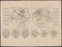
Published / Created:
1704
Call Number:
11 1704
Container / Volume:
BRBL_00004
Image Count:
1
Resource Type:
Maps, Atlases & Globes
Description:
Shows the two hemispheres in streographic projections, and below, each hemisphere in three views in orthographica projections. and Text: "Des differentes manieres de representer le globe terrestre en plan."
Publisher:
P. Moullart-Sanson,
Subject (Geographic):
World maps--Early works to 1800
Found in:
Beinecke Rare Book and Manuscript Library > Hemisphere occidental du globe terrestre ... Hemisphere oriental du globe terrestre ... par le Sieur Pierre Moullart-Sanson ...
Branch:v1.61.6 ,Deployed:2024-06-12T09:55:33-04:00