Search
You Searched For
Search Results
- Creator:
- Peirce, Benjamin, 1809-1880
United States Coast Survey
- Published / Created:
- 1869
- Call Number:
- 846cea Or4 1869
- Container / Volume:
- BRBL_00623
- Image Count:
- 1
- Resource Type:
- Maps, Atlases & Globes
- Found in:
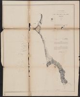
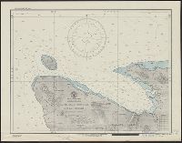
- Beinecke Rare Book and Manuscript Library > Cape Orford and reef, Oregon / U.S. Coast Survey, Benjamin Peirce, superintendant ; triangulation by A.W. Chase, sub-assistant in 1869 ; topography by A.M. Harrison, assist. and A.W. Chase, sub-assistant in 1851 & '69 ; hydrography by Commander J. Alden U
- Creator:
- U.S. Coast and Geodetic Survey
- Published / Created:
- 1898
- Call Number:
- 855hc 1898Q
- Container / Volume:
- BRBL_00765
- Image Count:
- 1
- Resource Type:
- Maps, Atlases & Globes
- Found in:
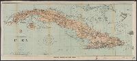
- Beinecke Rare Book and Manuscript Library > Cuba : part of chart "E" / Treasury Department, U.S. Coast and Geodetic Survey, Henry S. Pritchett, Superintendent.
- Creator:
- United States Coast Survey
- Published / Created:
- 1883
- Call Number:
- 761CEB 1883
- Container / Volume:
- BRBL_00449
- Image Count:
- 1
- Resource Type:
- Maps, Atlases & Globes
- Found in:
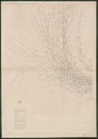
- Beinecke Rare Book and Manuscript Library > Gulf of Maine, current stations / United States Coast Survey.
- Creator:
- Maury, Matthew Fontaine, 1806-1873
- Published / Created:
- 1852-[1859?]
- Call Number:
- 11cfk 1850A-2
- Container / Volume:
- BRBL_00767
- Image Count:
- 4
- Resource Type:
- Maps, Atlases & Globes
- Found in:
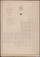
- Beinecke Rare Book and Manuscript Library > Maury's wind and current chart [cartographic material] : South Pacific / drawn by Lardner Gibbon, P.M. U.S.N.
- Creator:
- Maury, Matthew Fontaine, 1806-1873
- Published / Created:
- 1852-[1859?]
- Call Number:
- 11cfk 1850A-2
- Container / Volume:
- BRBL_00767
- Image Count:
- 1
- Resource Type:
- Maps, Atlases & Globes
- Found in:
- Beinecke Rare Book and Manuscript Library > Maury's wind and current chart [cartographic material] : South Pacific / drawn by Lardner Gibbon, P.M. U.S.N.
- Creator:
- Maury, Matthew Fontaine, 1806-1873
- Published / Created:
- [1854?]-1856.
- Call Number:
- 11cfk 1850A-5
- Container / Volume:
- BRBL_00769
- Image Count:
- 8
- Resource Type:
- Maps, Atlases & Globes
- Found in:
- Beinecke Rare Book and Manuscript Library > Maury's wind and current chart, Indian Ocean [cartographic material].
- Creator:
- Maury, Matthew Fontaine, 1806-1873
- Published / Created:
- 1853 [i.e. 1857]
- Call Number:
- 11cfk 1850C-2
- Container / Volume:
- BRBL_00770
- Image Count:
- 2
- Resource Type:
- Maps, Atlases & Globes
- Found in:
- Beinecke Rare Book and Manuscript Library > Pilot chart of the North Atlantic [cartographic material] / by M.F. Maury, L.L.D. Lieut. U.S. Navy ; superint'dt. of U.S.N. Observatory, Washington ; compiled from materials in the Bureau of Ordnance and Hydrography.
- Creator:
- Maury, Matthew Fontaine, 1806-1873
- Published / Created:
- 1859
- Call Number:
- 11cfk 1850C-10
- Container / Volume:
- BRBL_00772
- Image Count:
- 3
- Resource Type:
- Maps, Atlases & Globes
- Found in:
- Beinecke Rare Book and Manuscript Library > Pilot chart of the South Indian Ocean / by M.F. Maury, L.L.D. Comdr. U.S. Navy, Superin'dt. of U.S.N. Observatory, Washington ; compiled from materials in the Bureau of Ordnance and Hydrography by Lieuts. J.J. Guthrie, W.C. West & J.H. Carter, U.S.N.
- Creator:
- Pathfinder (Ship)
United States. Hydrographic Office
- Published / Created:
- 1944
- Call Number:
- 258 1944
- Container / Volume:
- BRBL_00022
- Image Count:
- 1
- Resource Type:
- Maps, Atlases & Globes
- Found in:
- Beinecke Rare Book and Manuscript Library > South Pacific Ocean Solomon Islands : Malaita Island North Coast, Suaba Harbor / U.S. Navy, Hydrographic Office.
- Creator:
- Maury, Matthew Fontaine, 1806-1873
- Published / Created:
- 1853
- Call Number:
- 11cfk 1850E-1
- Container / Volume:
- BRBL_00774
- Image Count:
- 1
- Resource Type:
- Maps, Atlases & Globes
- Found in:
- Beinecke Rare Book and Manuscript Library > Storm and rain chart of the North Atlantic [cartographic material] / by M.F. Maury, L.L.D. Lieut. U.S. Navy, Superin'dt of U.S.N. Observatory, Washington ; compiled from materials in the Bureau of Ordnance and Hydrography by Lieuts. George Minor, William H. Ball, & W. Rodgers Taylor, U.S. Navy ; eng. by Sherman & Smith N.Y.