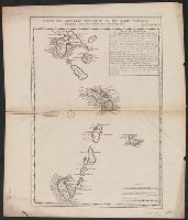
In upper right corner: Tom. VI, No. 35, pag. 154., Includes "Remarque historique" in upper right., Includes three bar scales: lieues communes de France, lieues marines de France et d'Angleterre, and lieues marines d'Espagne., and Sheet measures 53.6 x 45.4 cm. Ms. no.: 26.
Publisher:
s.n.,
Subject (Geographic):
Antilles, Lesser--Maps--Early works to 1800, West Indies, French--Maps--Early works to 1800, and Windward Islands (West Indies)--Maps--Early works to 1800
First state, with imprint date--Cf. Pedley. and Imperfect: torn, with no loss of text. Addressed in ms. on verso to Mr. M. Redmond Cross ... New York City ... from F.C. Carter ... Horning, N.Y. and postmarked. Ms. title on verso, with ms. no. 62. Hand col. Sheet measures 51 x 69 cm. Cross Collection no. 86.
Publisher:
Didie Robert de Vaugondy],
Subject (Geographic):
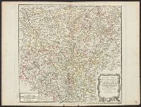
Germany--Maps--Early works to 1800
Subject (Name):
Carter, F. C.--Ownership, Cross, M. Redmond--Ownership, Haussard, Elisabeth, and Robert de Vaugondy, Gilles, 1688-1766. Atlas universel
Haussard, Elisabeth Robert de Vaugondy, Didier, 1723-1786 Robert de Vaugondy, Gilles, 1688-1766. Atlas universel
Published / Created:
ca. 1768?]
Call Number:
36 R34 1750
Container / Volume:
BRBL_00126
Image Count:
1
Resource Type:
Maps, Atlases & Globes
Description:
Appears in Robert de Vaugondy's Atlas universel ... Paris: Chez les auteurs, quay de l'Horloge du Palais, Boudet libraire imprimeur du roi, ruë St. Jacques, 1757., Ornamental cartouche., Relief shown pictorially., and Second state, without imprint date, with ma
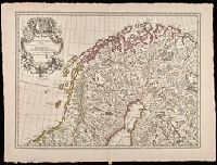
"Avec privilege du 30 Av. 1745"., Imprint below title: "A Paris, chez l'auteur ... avec privilege du Roy.", Includes embellished title cartouche with royal coat-of-arms., Prime meridian: Ferro., Relief shown by pictorially., and Watermarks. Sheets measure 53 x 72 cm. Manuscript number on verso, sheet 1: 28; on verso, sheet 2: 29.
Publisher:
Ph. Buache ...
Subject (Geographic):
Baltic States--Maps--Early works to 1800. and Scandinavia--Maps--Early works to 1800.
Subject (Name):
Buache, Philippe, 1700-1773 and Liebaux, Henri, -1752
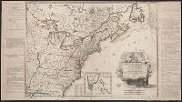
Includes notes, index to forts, and "Tableau ... de la population des Etats-Unis ... ", Local copy has no date following "confirmées par le traité définitif.", Prime meridians: Paris and Ferro., and Relief shown pictorially.
Inset list: "Les treize Etats-Unis.", Inset map: "Suplément a la Floride, même echelle que la carte.", Relief shown pictorially., Text from 1st state of, and Two leaves attached to the map: "Principaux evenemens militaires entre les Americains et les Anglois."
Publisher:
chez Delamarche,
Subject (Geographic):
United States--History--Revolution, 1775-1783--Maps--Early works to 1800 and United States--Maps--Early works to 1800
Subject (Name):
Delamarche, Charles François, 1740-1817 and Franklin, Benjamin, 1706-1790. dedication
La Rochefoucauld-Liancourt, François-Alexandre-Frédéric, duc de, 1747-1827
Published / Created:
1799]
Call Number:
755 1799C
Container / Volume:
BRBL_00436
Image Count:
1
Resource Type:
Maps, Atlases & Globes
Description:
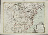
From La Rochefoucauld-Liancourt's Voyage dans les Etats Unis d'Amerique fait en 1795, 1796 et 1797. Paris : Chez Du Pont ... Buisson ... Charles Pougens ..., [1799], Relief shown pictorially., Sheet mea, and Title in French and place names in English.
Publisher:
Chez Du Pont ...,
Subject (Geographic):
Northeastern States--Maps--Early works to 1800
Subject (Name):
Du Pont, Imprimeur-Libraire and La Rochefoucauld-Liancourt, François-Alexandre-Frédéric, duc de, 1747-1827. Voyage dans les États Unis d'Amérique fait en 1795, 1796 et 1797