Skip to search
Skip to main content
Skip to first result
Search
You Searched For
Date
Unknown
Extent of Digitization
Unspecified
Genre
Engravings
Date Created
[Missing]
New Search
Search Results
Creator:
Call Number:
Zm Sp79
Collection Title:
Allgemeines historisches Taschenbuch, oder, Abriss der merkwurdigsten neuen Welt-Begebenheiten
Image Count:
1
Alternative Title:
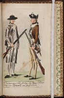
2. Regulaire Infanterie von Pensylvanien
Subject (Geographic):
United States --History --Colonial period, ca. 1600-1775 and United States --History --Revolution, 1775-1783
Subject (Topic):
Infantry
Collection Created:
Berlin : Haude und Spener, [1783]
Found in:
Beinecke Rare Book and Manuscript Library > 1. Americanischer Scharffschuetz oder Faeger, (rifleman)
Call Number:
Egf 789
Collection Title:
The American geography; or, A view of the present situation of the United States of America
Image Count:
1
Description:
Preceding p. 33.
Subject (Geographic):
France --History --Revolution, 1789-1799, United States --Description and travel, and United States --Maps --Early works to 1800
Subject (Topic):
Geography --Textbooks --Early works to 1800 and Maps --United States --1788
Collection Created:
Elizabeth Town : Printed by Shepard Kollock, for the author, M,DCC,LXXXIX
Found in:
Beinecke Rare Book and Manuscript Library > A Map of the northern and middle states; comprehending the western Territory and the British dominions in North America. Compiled from the best authorities
Call Number:
Taylor 376
Collection Title:
The discoveries of John Lederer : in three several marches from Virginia, to the west of Carolina
Image Count:
1
Description:
Engraved by Cross. and Preceding title page.
Subject (Geographic):
North Carolina --Description and travel, North Carolina --Maps --Early works to 1800, Virginia --Description and travel, and Virginia --Maps --Early works to 1800
Subject (Name):
Talbot, William
Subject (Topic):
Indians of North America --North Carolina and Indians of North America --Virginia
Collection Created:
London, Printed by J.C. for S. Heyrick, 1672
Found in:
Beinecke Rare Book and Manuscript Library > A Map of the whole territory traversed by John Lederer in his three marches
Call Number:
Zc10 869be
Collection Title:
New tracks in North America. A journal of travel and adventure whilst engaged in the survey for a
Image Count:
1
Description:
P. 225.
Subject (Geographic):
Southwest, New --Description and travel
Subject (Topic):
Indians of North America --Southwest, New and Pacific railroads --Explorations and surveys
Collection Created:
London, Chapman & Hall, 1869
Found in:
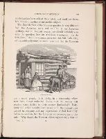
Beinecke Rare Book and Manuscript Library > A Mormon family
Creator:
Call Number:
1979 Folio 89
Collection Title:
Plates to Cook’s Thurd voyage
Image Count:
1
Subject (Geographic):
Hawaii
Subject (Topic):
Hawaiians and Indians of North America --Clothing
Collection Created:
[London? Printed by V. and A. Strahan, for G. Nicol, & T. Cadell? 1784?]
Found in:
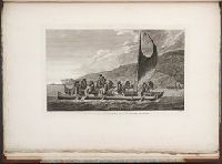
Beinecke Rare Book and Manuscript Library > A canoe of the Sandwich Islands, the rowers masked, pl. 65
Call Number:
Zc10 807gae
Collection Title:
A journal of the voyages and travels of a corps of discovery, under the command of Capt. Lewis and
Image Count:
1
Description:
Associated with p. 220.
Subject (Geographic):
Columbia River, Missouri River, and West (U.S.) --Description and travel
Subject (Name):
Lewis and Clark Expedition (1804-1806)
Collection Created:
Philadelphia, Printed for Mathew Carey, 1812
Found in:
Beinecke Rare Book and Manuscript Library > A canoe striking on a tree
Call Number:
1978 Folio 10
Collection Title:
The English pilot: describing the West-India navigation, from Hudson's-Bay to the river Amazones
Image Count:
2
Subject (Geographic):
Atlantic Ocean --Maps --Early works to 1800 and West Indies --Maps --Early works to 1800
Subject (Topic):
Navigation --Early works to 1800, Pilot guides --Atlantic Coast (U.S.) --Early works to 1800, and Pilot guides --Caribbean Area --Early works to 1800
Collection Created:
London : Printed for Thomas Page, William and Fisher Mount, in Postern-Row on Tower-hill, MDCCXXV [1725]
Found in:
Beinecke Rare Book and Manuscript Library > A chart of the Caribe Islands
Call Number:
1973 Folio 76
Collection Title:
The English pilot: describing the sea-coasts, capes, head-lands, rivers, bays, roads, havens
Image Count:
1
Description:
Most maps numbered in pencil on verso, some on recto.
Subject (Geographic):
Atlantic Ocean --Maps --Early works to 1800 and West Indies --Maps --Early works to 1800
Subject (Topic):
Navigation --Early works to 1800, Pilot guides --Atlantic Coast (U.S.) --Early works to 1800, and Pilot guides --Caribbean Area --Early works to 1800
Collection Created:
London : Printed for John Thornton, at the sign of the England, Scotland, and Ireland, in the Minories, and Richard Mount, at the Postern on Tower-Hill, 1698London : Printed for John Thornton, at the sign of the England, Scotland, and Ireland, in the Minories, and Richard Mount, at the Postern on Tower-Hill, 1698
Found in:
Beinecke Rare Book and Manuscript Library > A chart of the Caribe ilands
Call Number:
1976 1233
Collection Title:
Forty-two new maps of Asia, Africa, and America ... : all engrav’d, according to the latest
Image Count:
1
Alternative Title:
A chart of the South Sea coast from the Streights of Magellan to Arica and A chart of the South-Sea coast
Description:
In pencil on verso: 26. and Table of contents for maps 2-20 in section "America" misnumbered.
Subject (Geographic):
Arica (Chile), Chile --Maps --Early works to 1800, South America --Maps --Early works to 1800, and Tierra del Fuego (Argentina and Chile)
Subject (Name):
Nicholson, John, d. ca. 1717, bookseller
Subject (Topic):
Atlases --Early works to 1800
Collection Created:
London : Printed for J. Nicholson ..., 1716 ...
Found in:
Beinecke Rare Book and Manuscript Library > A chart of the South Sea coast from the Steights [sic] of Magellan to Arica
Call Number:
1976 1233
Collection Title:
Forty-two new maps of Asia, Africa, and America ... : all engrav’d, according to the latest
Image Count:
1
Alternative Title:
Streights of Magellan, by Sr. F. Narborough
Description:
In ink on verso: 24. and Table of contents for maps 2-20 in section "America" misnumbered.
Subject (Geographic):
Magellan, Strait of (Chile and Argentina) --Maps --Early works to 1800 and Tierra del Fuego (Argentina and Chile)
Subject (Name):
Nicholson, John, d. ca. 1717, bookseller
Subject (Topic):
Atlases --Early works to 1800
Collection Created:
London : Printed for J. Nicholson ..., 1716 ...
Found in:
Beinecke Rare Book and Manuscript Library > A chart of the Streights of Magellan
Branch:v1.61.6 ,Deployed:2024-06-12T09:55:31-04:00