Skip to search
Skip to main content
Skip to first result
Search
You Searched For
Genre
Maps
Language
German
Subject (Topic)
World War, 1914-1918--Maps
New Search
Search Results
Published / Created:
1916.]
Call Number:
11hc 1916D
Container / Volume:
BRBL_00010C
Image Count:
2
Resource Type:
Maps, Atlases & Globes
Alternative Title:
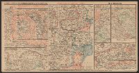
Wochentliche Kriegsschauplatzkarte
Description:
Shows German military actions between October 23-30, 1916.
Publisher:
Rud. Mayer,
Subject (Geographic):
Europe--Maps
Subject (Topic):
World War, 1914-1918--Maps
Found in:
Beinecke Rare Book and Manuscript Library > Die militärischen ereignisse vom 23, bis 30. October 1916 : Wochentliche Kriegsschauplatzkarte.
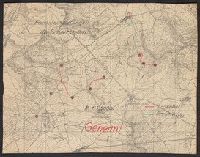
Published / Created:
1918?]
Call Number:
38hc 1918A Sep. folder
Container / Volume:
BRBL_00172
Image Count:
1
Resource Type:
Maps, Atlases & Globes
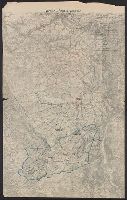
Description:
Accompanied by sheet containing overlay diagrams "Sperrfeuer Remenauville" and "Sperrfeuer: Mort-Mare-Wald". and Ms. annotations in German. Imperfect: cut around borders.
Publisher:
s.n.,
Subject (Geographic):
Champagne-Ardenne (France)--Maps and Lorraine (France)--Maps
Subject (Topic):
Electric lines, Telephone lines, World War, 1914-1918--France--Lorraine, and World War, 1914-1918--Maps
Found in:
Beinecke Rare Book and Manuscript Library > Fernsprechleitungen der Schaltstellen.
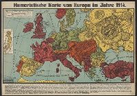
Published / Created:
[1914]
Call Number:
30 1914D
Container / Volume:
BRBL_00032A
Image Count:
1
Resource Type:
Maps, Atlases & Globes
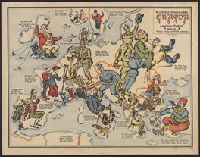
Description:
Caricature map., Ill. of people and animals represent international relations., and Includes inset of Japan and text.
Publisher:
Leutert & Schneidewind,
Subject (Geographic):
Europe--Maps and Japan--Maps
Subject (Topic):
International relations--20th century--Maps, World War, 1914-1918--Caricatures and cartoons, and World War, 1914-1918--Maps
Found in:
Beinecke Rare Book and Manuscript Library > Humoristische karte von Europa im Jahre 1914.
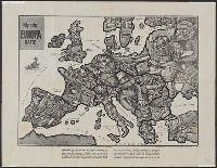
Creator:
Published / Created:
[1914]
Call Number:
30an 1914C
Container / Volume:
BRBL_00037A
Image Count:
1
Resource Type:
Maps, Atlases & Globes
Description:
Caricature map., Countries are represented by human and animal caricatures to depict political issues., and Includes text.
Publisher:
W. Nölting,
Subject (Geographic):
Europe--Maps and Europe--Politics and government--Maps
Subject (Topic):
World War, 1914-1918--Maps
Found in:
Beinecke Rare Book and Manuscript Library > Satyrische Europa Karte, Weltkrieg 1914 / Zeichnung u. Entwurf, E. Zimmermann.
Creator:
Published / Created:
1915
Call Number:
30 1915G
Container / Volume:
BRBL_00032A
Image Count:
2
Resource Type:
Maps, Atlases & Globes
Description:
"Zensur Altona 603.", Caricature map., Caricatures represent international relations., and Includes text.
Publisher:
L. Gräfe,
Subject (Geographic):
Europe--Maps
Subject (Topic):
International relations--20th century--Maps, World War, 1914-1918--Caricatures and cartoons, and World War, 1914-1918--Maps
Found in:
Beinecke Rare Book and Manuscript Library > Sommerschau über Europa 1915 : erweiterte Massstab, 3 gegen 8 / A.K. gez. u. lith.
Published / Created:
1918
Call Number:
38hc 1918 Sep. folder
Container / Volume:
BRBL_00172
Image Count:
1
Resource Type:
Maps, Atlases & Globes
Description:
"Druck der Vermess. Abt. 2"., Legend indicates voltage, power lines, transformer stations, power switching stations, front line., Ms. annotations in German. Imperfect: cut around borders., and On verso: Ms. notes: "Komp.-Karte".
Publisher:
s.n.,]
Subject (Geographic):
Lorraine (France)--Maps
Subject (Topic):
Electric lines, World War, 1914-1918--France--Lorraine, and World War, 1914-1918--Maps
Found in:
Beinecke Rare Book and Manuscript Library > Verdun-Point-à-Mousson.
Published / Created:
[1915?]
Call Number:
11hcf 1919A-32
Container / Volume:
BRBL_00010N
Image Count:
1
Resource Type:
Maps, Atlases & Globes
Alternative Title:
Pola, Zara, Comacchio
Description:
"B.4." in upper left margin., "Teilweise berichtigt bis I. V. 1915.", and Stamped "American Geographical Society" above left margin and "Loaned by the American Geographical Society, Broadway at 136th St., New York to The Peace Conference at Versailles 1918-1919
Publisher:
K.u.K. Militär geographisches Institut,
Subject (Geographic):
Croatia--Maps and Italy--Maps
Subject (Topic):
World War, 1914-1918--Maps
Found in:
Beinecke Rare Book and Manuscript Library > [Regional map of the area around the Adriatic Sea : showing the cities of Pola, Zara, Comacchio] / K.u.K. Militärgeographisches Institut.
Published / Created:
191-.
Call Number:
11hc 1915R
Container / Volume:
BRBL_00010C
Image Count:
2
Resource Type:
Maps, Atlases & Globes
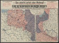
Description:
Includes 2 maps, text, and ill. and On verso: 4 anciallry maps, text, and ill.
Publisher:
Julius Hans Forkel,
Subject (Geographic):
Germany--Maps
Subject (Topic):
World War, 1914-1918--Maps
Found in:
Beinecke Rare Book and Manuscript Library > [So steht jetzt der Krieg!] : Kriegsoperationskarte über alle Kriegsschauplätze der welt.
Branch:v1.64.0 ,Deployed:2024-09-11T10:25:40-04:00