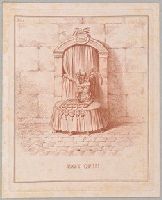
"Time stands behind an oval table covered with a cloth on which is an hour-glass, its sands nearly run out, standing on a large flat book inscribed 'Traitè de Paix', from which five seals hang evenly. Behind him is a doorway in a stone wall, covered with a curtain, one side of which he holds. With his left forefinger he points upwards at the inscription above the door: 'L'avenir', which is decorated with seven (drooping) ears of corn. The seals are inscribed (left to right): 'F.W.' [Frederick William of Prussia]; 'G Rx', with its ribbon inscribed 'God save the King'; France; a crowned 'C' [Catherine II]; 'Fr. Imp.' [Francis Imperator] (prophetic of the powers that decided the fate of Holland in 1815). 'Le génie du Terns garde la porte de l'avenir;... Qui est le mortel assez hardi, pour oser le penetrer? . . .' Text, 'Proverbs', x. 28. To this is added, in English only, 'St. Matthew', v. 9, 'Blessed are the peacemakers!'"--British Museum online catalogue.
Description:
Artist identified as Hess and printmaker questionably identified as Gillray in the British Museum catalogue., One of twenty plates published as a bound set entitled: Hollandia regenerata., Place and date of publication from British Museum catalogue., Plate numbered "20" in upper left corner., Possibly published by Hannah Humphrey. See British Museum catalogue., Temporary local subject terms: Holland: civil discord -- Emblems: hour-glass -- Personifications: Time -- Seven ears of wheat-corn as United Provinces., Title etched below image., and With: Letterpress explanation in French that includes appropriate texts from the Bible in Dutch and in English.
Subject (Name):
Auchincloss, Hugh Dudley--Ownership., Harvey, Francis--Ownership., and Hess, David, 1770-1843, artist.
Mortier, David Mortier, Pierre Sanson, Nicolas, 1600-1667, creator
Published / Created:
[1710]
Call Number:
1973 Folio 10
Image Count:
1
Resource Type:
Maps, Atlases & Globes
Alternative Title:
Premiere carte de la Meuse avec les pais, duchez et comtez voisins and Teatre de la guerre en Flandre et Brabant
Description:
Alternate title in upper margin: Premiere carte de la Meuse avec les pais, duchez et comtez voisins., Does not show troop positions or other military locations., Ferro meridian., Imperfect: western sheet (with title cartouche) wanting. Part of eastern map (inset of Arras/Cambrai region) pasted over correction[?]., Includes inset of Arras/Cambrai region and color illustration of battles at upper left and lower right., No. 47 of 69 maps bound together in composite atlas., Originally printed on 4 sheets., Presentee a son altesse Monseigneur le Duc & Comte [sic] de Marlborough, Marquis de Blandford, &c. &c. &c., par son tres-humble et tres-obeissant serviteur, Pierre Mortier, libraire a Amsterdam., Relief shown pictorially., and Scale [ca. 1:250 000].
Publisher:
Apud Petrum Mortier, et se vend a Londres chez David Mortier
Subject (Topic):
Spanish Succession, War of, 1701-1714 --Maps --Early works to 1800