Skip to search
Skip to main content
Skip to first result
Search
You Searched For
Resource Type
Maps, Atlases & Globes
Language
Italian
New Search
Search Results
Creator:
Published / Created:
1820]
Call Number:
400cb R66 1820
Container / Volume:
BRBL_00233
Image Count:
1
Resource Type:
Maps, Atlases & Globes
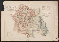
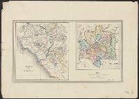
Description:
400cb R66 1820: Separated into 2 sheets., Designed to accompany the author's "Dello stato fisico del suolo di Roma"., Relief shown by hachures., and Shows locations of soils color-coded by type.
Publisher:
s.n.,
Subject (Geographic):
Rome (Italy)--Maps
Subject (Name):
Brocchi, Giovanni Battista. Dello stato fisico del suolo di Roma, Campi, fl. 1820, and Ruga, Pietro
Subject (Topic):
Geography, Ancient--Maps and Soils--Italy--Rome--Maps
Found in:
Beinecke Rare Book and Manuscript Library > Carta fisica del suolo di Roma ne' primi tempi della fondazione di questa città [cartographic material] / di G. Brocchi ; Campi dis. ; Pietro Ruga inc.
Published / Created:
[1910?]
Call Number:
40gm 1910
Container / Volume:
BRBL_00229
Image Count:
2
Resource Type:
Maps, Atlases & Globes
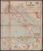
Alternative Title:
Carta delle ferrovie principali di Europa della Colonia Eritrea e della Libia
Description:
Includes 10 inset maps, each showing a close-up view of a city or region.
Publisher:
Fratelli Pozzo,
Subject (Geographic):
Europe--Maps and Italy--Maps
Subject (Topic):
Ocean travel--Adriatic Sea--Maps, Ocean travel--Western Mediterranean--Maps, and Railroads--Italy--Maps
Found in:
Beinecke Rare Book and Manuscript Library > Carta generale delle strade ferrate Italiane e linee di navigazione.
Published / Created:
1911
Call Number:
BrSides Double Folio 2019 94
Image Count:
2
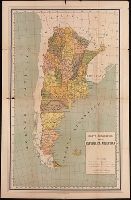
Resource Type:
Maps, Atlases & Globes
Alternative Title:
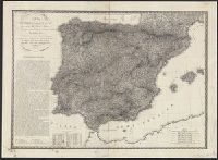
Ricordo della repubblica Argentina all' Esposizione Internazionale delle Industrie e del Lavoro di Torino, 1911
Description:
Descriptive text on verso compiled by Alberto B. Martinez. and Relief shown by hachure.
Publisher:
Comite argentino,
Subject (Geographic):
Argentina--Description and travel and Argentina--Maps
Subject (Name):
Martínez, Alberto B.
Found in:
Beinecke Rare Book and Manuscript Library > Carta geografica della repubblica Argentina.
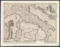
Creator:
Published / Created:
1750]
Call Number:
40 1760A
Container / Volume:
BRBL_00197
Image Count:
1
Resource Type:
Maps, Atlases & Globes
Description:
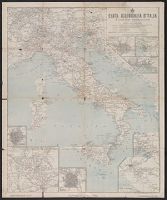
Appears in Guillaume de l'Isle's Atlante novissimo, vol. 2, pl. 17 (plate only num, Imperfect: Mutilated, with some loss of text. Mounted on linen. Sheet measures 38 x 49 cm. dgvmp2008., Includes scale in Italian miles., and Inset: Il regno di Sicilia.
Publisher:
Giambatista Albrizzi q. Girol.,
Subject (Geographic):
Italy--Maps--Early works to 1800
Found in:
Beinecke Rare Book and Manuscript Library > Carta geografica generale dell' Italia.
Branch:v1.61.8 ,Deployed:2024-06-20T11:14:55-04:00