Skip to search
Skip to main content
Skip to first result
Search
You Searched For
Format
cartographic
Publication Place
Boston :
New Search
Search Results
Published / Created:
1880
Call Number:
754cea B98 1880
Container / Volume:
BRBL_00418
Image Count:
2
Resource Type:
Maps, Atlases & Globes
Alternative Title:
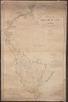
Buzzards Bay and Chart no. 10 Buzzard's Bay
Description:
Depths shown by soundings. Distance shown, Includes abbreviations of types of bottoms, references, and tides., Mounted on linen. Includes adv. for "American Ship Windlass Company, Providence, R.I.", and Shows lighthouses, bouys, ferries, and some coastal towns.
Publisher:
S. Thaxter & Son,
Subject (Geographic):
Buzzards Bay (Mass.)--Maps
Subject (Name):
Eldridge, George W
Subject (Topic):
Nautical charts--Massachusetts--Buzzards Bay
Found in:
Beinecke Rare Book and Manuscript Library > Eldridge's chart no. 10 : Buzzard's Bay, from the United States Coast and George Eldridge's surveys / published by Thaxter & Son. 125 State St. Boston, 1880.
Creator:
Published / Created:
1891
Call Number:
764cea B65 1891E
Container / Volume:
BRBL_00461
Image Count:
1
Resource Type:
Maps, Atlases & Globes
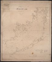
Description:
"Entered according to Act of Congress in the year 1865 by Samuel T. Cushing in the Clerk's Office of the District Court of the District of Massachusetts." outs, Includes "Sailing Directions"., and Relief shown by hachures. Depths shown by soundings and shading.
Publisher:
S. Thaxter & Son,
Subject (Geographic):
Boston Harbor (Mass.)--Maps
Subject (Name):
Boynton, George W., d. 1884 and S. Thaxter & Son
Subject (Topic):
Nautical charts--Massachusetts--Boston Harbor
Found in:
Beinecke Rare Book and Manuscript Library > Eldridge's new chart of Boston Harbor : compiled from the latest surveys / engraved by G.W. Boynton.
Creator:
Published / Created:
[1843]
Call Number:
BrSides 2019 109
Image Count:
2
Resource Type:
Maps, Atlases & Globes
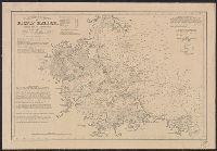
Description:
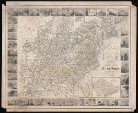
Imperfect: chipped. Autograph on verso: J.H. Chickering, Jan. 29, 1850., Includes inset maps: N. part of Michigan; N. part of Maine; Plan of Washington; S. part of Florida., Map surrounded by thirty-eight vingettes., and Prime meridian: Washington, D.C.
Publisher:
[Goodyear?],
Subject (Geographic):
United States--Maps.
Subject (Name):
Chickering, J. H.--Autograph.
Subject (Topic):
Counties--United States--Maps.
Found in:
Beinecke Rare Book and Manuscript Library > Goodyear's miniature county map of the United States / engraved by J.H. Goldthwait.
Creator:
Published / Created:
1907
Call Number:
802 M31 1907
Container / Volume:
BRBL_00542
Image Count:
1
Resource Type:
Maps, Atlases & Globes
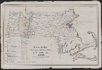
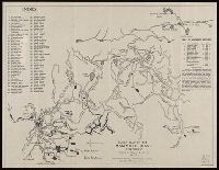
Description:
"From former surveys, with recent additions." and Includes index and table of distances.
Publisher:
Geo. H. Walker & Co.,
Subject (Geographic):
Mammoth Cave (Ky.)--Maps
Subject (Name):
Geo. H. Walker & Co
Subject (Topic):
Caves--Kentucky--Mammoth Cave--Maps
Found in:
Beinecke Rare Book and Manuscript Library > Guide map of the Mammoth Cave, Kentucky / drawn by Horace C. Hovey.
Branch:v1.61.6 ,Deployed:2024-06-12T09:55:33-04:00