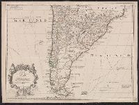
Appears in L'Isle's Atlas de géographie. Paris : Guillaume DeLisle, Quai de l'Horloge, 1731., Or, Relief shown pictorially., Sheet measures 54.9 x 74.6 cm., and Shows routes of Magellan, Sarmiento, Brower, Beauchesne, Sharp, Sr. de la Roche, Halley and Vespucci.
Publisher:
Chez l'auteur sur le Quai de l'Horloge ...,
Subject (Geographic):
South America--Maps--1708-1718 and South America--Maps--Early works to 1800
Subject (Name):
Liebaux, engraver, L'Isle, Guillaume de, 1675-1726. Atlas de géographie, and Simonneau, Charles, 1645-1728
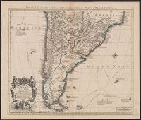
Appears in L'Isle's Atlas de géographie. Paris : Guillaume DeLisle, Quai de l'Horloge, 1731., Imprint of Louis Renard Libraire, Mounted in linen. Sheet measures 51.8 x 69.7 cm., Ornamental cartouche by "C. Simonneau inv. et fecit.", and Relief shown pictorially.
Publisher:
Chez l'auteur sur le Quai de l'Horloge ...,
Subject (Geographic):
South America--Maps--1708-1718 and South America--Maps--Early works to 1800
Subject (Name):
Liebaux, engraver, L'Isle, Guillaume de, 1675-1726. Atlas de géographie, and Simonneau, Charles, 1645-1728
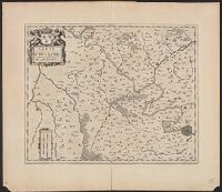
Tabula geographica Paragaiae, Chilis, Freti a Magellanici &c
Description:
Appears in Cóvens and Mortier's Atlas nouveau; cf. Koeman, C. Atlantes Neerlandici, II C & M 4., Bar scales given in "lieues marines d'Espagne" and "lieues comm. d'Espagne"., Cross Collection no. 327., Mounted in linen., Relief shown pictorially., and Shows southern part of South American continent.
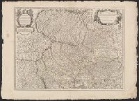
"Avec privilege"., "Desrosiers ... à Amsterdam chez Louis Renard"--Obscured print in lower left margin of southern sheet., Covers northwestern Italy., Hand colored. Stamp: Karp, Inset: Environs de Nice et de Ville-franche., and Relief shown pictorially.
Publisher:
chez l'auteur,
Subject (Geographic):
Monferrato (Italy)--Maps--Early works to 1800 and Piedmont (Italy)--Maps--Early works to 1800
Subject (Name):
Desrosiers, Liebaux, Henri, -1752, and Renard, Louis, approximately 1678-
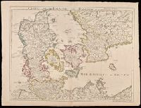
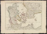
"Avec privilege du 30 Av. 1745"., Imprint in lower left: "A Paris chez l'auteur ... ", Prime meridian: Ferro., Relief shown pictorially., and Watermarks. Sheet measures 54 x 72 cm. Manuscript note on verso: 30.
Publisher:
Ph. Buache ...
Subject (Geographic):
Denmark--Maps--Early works to 1800., Schleswig-Holstein (Germany)--Maps--Early works to 1800., and Sweden--Maps--Early works to 1800.