All volumes bound to match 1973 Folio 72. Factitious collection of about 549 maps taken from the atlases of the 17th and the beginning of the 18th cent., put together with the title "Atlas" and bound in 6 volumes. These volumes originally bore the imprint: Amstelaedamii apvd Reiniervm & Josvam Ottens. Over these words on the title-pages of v. 1-2, 4-6 is the name of Henrik de Leth who painted them. Volume 3 has only the erased imprint of Ottens., For fuller description see Phillips 3448 and C. Koeman's Atlantes Neerlandici, bibliography of terrestrial, maritime and celestial atlases and pilot books, published in the Netherlands up to 1800, Amsterdam c1967-71, v. 2, p. 63-83., and Maps by P. Schenck and son, G. Valck, F. de Wit, N. Visscher and others.
Publisher:
chez J. Covens & C. Mortier,
Subject (Geographic):
Denmark --Maps --Early works to 1800
Subject (Name):
Reiner et Josua Ottens (Firm), Schenk, Peter, 1660-1718 or 1719., and Valck, G. (Gerard), 1651 or 1652-1726.
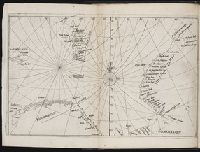
Descriptio ac delineatio geographica detectionis freti, sive, transitus ad occasum supra terras
Image Count:
1
Description:
Bound in after p. [40]., Map has water stain on recto in upper right corner., Printed on recto in lower right corner: F., and Scale [ca. 1:10,000,000].
Subject (Geographic):
Barents Sea --Maps --Early works to 1800. and Norwegian Sea --Maps --Early works to 1800
Collection Created:
Amsterodami Ex officina Hesse lij Gerardi. Anno 1613
Bookseller's labels: Landbergs; G. Hedberg ... Stockholm. Bookplate of Alarik Waghtmeister. Manuscript annotations on front paste-down endpaper of cover; title on cover "Johan Monssons Karta öfver Östersjön.", Coordinates not present on map and are approximated., Depths shown by soundings., Includes dedication from "Johan Mansson.", North oriented towards the bottom., Title devised by cataloger., and Watermark.
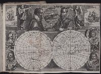
Journal ou relation exacte du voyage de Guill Schouten
Image Count:
1
Description:
Bound in after p. [8]., Busts of various explorers depicted around edges of map., Four small areas with stains on verso., Scale not given., and Western hemisphere of North and South America hand colored.
Subject (Topic):
Oceania --Discovery and exploration --Early works to 1800, Voyages around the world --Early works to 1800, and World maps --Early works to 1800
Collection Created:
A Paris : chez M. Gobert, au Palais en la gallerie des prisonniers, et les cartes, chez M. Tauernier, graueur du roy, demeurant au pont Marchand, 1618