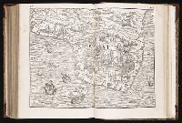
Brightstovve, vulgo; quondam venta, floretissimum Angliae Emporium and Civitates orbis terrarum.
Description:
Mounted on sheet. Annotation on sheet: "Hoefnagel's map of Bristol, 1581 (Braun's Civitates). It shows Broad Stt., where the tennis court stood (1636). Preliminary record.
Navtica mediterranea / di Bartolomeo Crescentio Romano ... Nella quale si mostra la fabrica delle
Image Count:
1
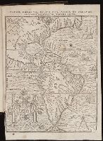
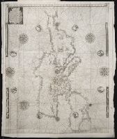
Description:
Map bound in at end., Map cut and folded irregularly., Map done on two separate sheets and pasted together in center., Map has several small gray and black smudges on both the recto and verso that appear to be fingerprints left during the engraving process., Map has several small yellow and brown marks, most notably on verso, although one can be seen on recto in lower right section., and Scale [ca. 1:6,500,000].
Subject (Geographic):
Mediterranean Region --Maps --Early works to 1800 and Mediterranean Sea --Navigation --Early works to 1800
Subject (Topic):
Galleys --Early works to 1800, Navigation --Early works to 1800, and Pilot guides --Mediterranean Sea --Early works to 1800
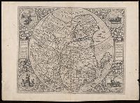
Appeared in Jode's Speculum orbis terrarum, Blank on verso., Engraving attributed to Antonie Wierix., Manuscript number on verso "No. 114.", Margins include descriptive text and four allegorical-historical vignettes (each 7 cm in diameter)., Relief shown pictorially., and Watermark.