
You Searched For
« Previous
| 55 - 62 of 62 |
Next »
Search Results
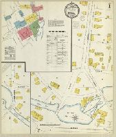
55. Milford, New Haven County, Conn.
- Creator:
- Sanborn-Perris Map Co., issuing body
- Published / Created:
- 1900
- Call Number:
- 766 M59 1900
- Image Count:
- 8
- Resource Type:
- Maps, Atlases & Globes
- Abstract:
- Sanborn fire insurance maps are a rich source of historic data on the urban built environment of North America during the 19th and early 20th centuries. The atlases were created for the purpose of underwriting fire insurance policies, which depended upon accurate and frequently-updated information about construction materials, municipal and transportation infrastructure, industrial and commercial landuse and more. The Yale University Library Map Department scanned its holdings of Sanborn fire insurance maps (consisting primarily of Connecticut towns) in order to make the maps more accessible.
- Alternative Title:
- Dec. 1900, Milford, Conn.
- Description:
- "6 sheets. 4393.", Contains information on population, prevailing winds, water facilities and fire department., Includes index of streets and specials., Partial cadastral map., Sheets 7-8 include subtitle: "Woodmont.", and SMLMAPL 766 M59 1900: Sheets disbound. "Triplicate" stamp on all sheets. Library of Congress copyright stamp on title sheet.
- Subject (Geographic):
- Milford (Conn.)--Maps
- Subject (Name):
- Library of Congress Stamp
- Subject (Topic):
- Fire risk assessment--Connecticut--Milford--Maps and Real property--Connecticut--Milford--Maps
- Found in:
- Beinecke Rare Book and Manuscript Library > Milford, New Haven County, Conn.
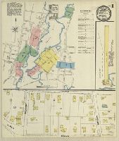
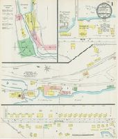
56. Mystic, New London Co., Conn.
- Creator:
- Sanborn-Perris Map Co., issuing body
- Published / Created:
- 1891
- Call Number:
- 766 M992 1891
- Image Count:
- 5
- Resource Type:
- Maps, Atlases & Globes
- Abstract:
- Sanborn fire insurance maps are a rich source of historic data on the urban built environment of North America during the 19th and early 20th centuries. The atlases were created for the purpose of underwriting fire insurance policies, which depended upon accurate and frequently-updated information about construction materials, municipal and transportation infrastructure, industrial and commercial landuse and more. The Yale University Library Map Department scanned its holdings of Sanborn fire insurance maps (consisting primarily of Connecticut towns) in order to make the maps more accessible.
- Alternative Title:
- Apr. 1891, Mystic, Conn.
- Description:
- "5 sheets. 4350.", Contains information on population, prevailing winds, water facilities and fire department., Includes index of specials., Partial cadastral map., and SMLMAPL 766 M992 1891: Sheets disbound. "Triplicate" stamp on all sheets. Library of Congress copyright stamp on title sheet.
- Subject (Geographic):
- Mystic (Conn.)--Maps
- Subject (Name):
- Library of Congress Stamp
- Subject (Topic):
- Fire risk assessment--Connecticut--Mystic--Maps and Real property--Connecticut--Mystic--Maps
- Found in:
- Beinecke Rare Book and Manuscript Library > Mystic, New London Co., Conn.
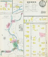
57. Naugatuck, New Haven Co., Connecticut.
- Creator:
- Sanborn-Perris Map Co., issuing body
- Published / Created:
- 1892
- Call Number:
- 766 N22 1892
- Image Count:
- 5
- Resource Type:
- Maps, Atlases & Globes
- Abstract:
- Sanborn fire insurance maps are a rich source of historic data on the urban built environment of North America during the 19th and early 20th centuries. The atlases were created for the purpose of underwriting fire insurance policies, which depended upon accurate and frequently-updated information about construction materials, municipal and transportation infrastructure, industrial and commercial landuse and more. The Yale University Library Map Department scanned its holdings of Sanborn fire insurance maps (consisting primarily of Connecticut towns) in order to make the maps more accessible.
- Alternative Title:
- Aug. 1892, Naugatuck, Conn.
- Description:
- "5 sheets. 5431.", Contains information on population, prevailing winds, water facilities and fire department., Includes index of specials., Partial cadastral map., and SMLMAPL 766 N22 1892: Sheets disbound. "Triplicate" stamp on all sheets. Library of Congress copyright stamp on title sheet.
- Subject (Geographic):
- Naugatuck (Conn.)--Maps
- Subject (Name):
- Library of Congress Stamp
- Subject (Topic):
- Fire risk assessment--Connecticut--Naugatuck--Maps and Real property--Connecticut--Naugatuck--Maps
- Found in:
- Beinecke Rare Book and Manuscript Library > Naugatuck, New Haven Co., Connecticut.
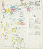
58. Naugatuck, New Haven County, Conn.
- Creator:
- Sanborn-Perris Map Co., issuing body
- Published / Created:
- 1897
- Call Number:
- 766 N22 1897
- Image Count:
- 7
- Resource Type:
- Maps, Atlases & Globes
- Abstract:
- Sanborn fire insurance maps are a rich source of historic data on the urban built environment of North America during the 19th and early 20th centuries. The atlases were created for the purpose of underwriting fire insurance policies, which depended upon accurate and frequently-updated information about construction materials, municipal and transportation infrastructure, industrial and commercial landuse and more. The Yale University Library Map Department scanned its holdings of Sanborn fire insurance maps (consisting primarily of Connecticut towns) in order to make the maps more accessible.
- Alternative Title:
- Sep. 1897, Naugatuck, Conn.
- Description:
- "7 sheets. (1462).", Contains information on population, prevailing winds, water facilities and fire department., Includes index of streets and specials., Partial cadastral map., and SMLMAPL 766 N22 1897: Sheets disbound. "Triplicate" stamp on all sheets. Library of Congress copyright stamp on title sheet.
- Subject (Geographic):
- Naugatuck (Conn.)--Maps
- Subject (Name):
- Library of Congress Stamp
- Subject (Topic):
- Fire risk assessment--Connecticut--Naugatuck--Maps and Real property--Connecticut--Naugatuck--Maps
- Found in:
- Beinecke Rare Book and Manuscript Library > Naugatuck, New Haven County, Conn.
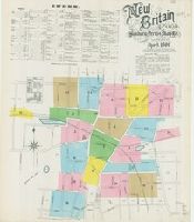
59. New Britain, Hartford Co., Conn.
- Creator:
- Sanborn-Perris Map Co., issuing body
- Published / Created:
- 1890
- Call Number:
- 766 N42 1890
- Image Count:
- 19
- Resource Type:
- Maps, Atlases & Globes
- Abstract:
- Sanborn fire insurance maps are a rich source of historic data on the urban built environment of North America during the 19th and early 20th centuries. The atlases were created for the purpose of underwriting fire insurance policies, which depended upon accurate and frequently-updated information about construction materials, municipal and transportation infrastructure, industrial and commercial landuse and more. The Yale University Library Map Department scanned its holdings of Sanborn fire insurance maps (consisting primarily of Connecticut towns) in order to make the maps more accessible.
- Alternative Title:
- April 1890, New Britain, Conn.
- Description:
- "19 sheets. (3742).", Contains information on population, water facilities, and fire department., Includes index of streets and specials., Partial cadastral map., and SMLMAPL 766 N42 1890: Sheets disbound. "Triplicate" stamp on all sheets. Library of Congress manuscript note on title sheet.
- Subject (Geographic):
- New Britain (Conn.)--Maps
- Subject (Name):
- Library of Congress Ownership
- Subject (Topic):
- Fire risk assessment--Connecticut--New Britain--Maps and Real property--Connecticut--New Britain--Maps
- Found in:
- Beinecke Rare Book and Manuscript Library > New Britain, Hartford Co., Conn.
60. New Hartford, Lichfield Co., Conn.
- Creator:
- Sanborn-Perris Map Co., issuing body
- Published / Created:
- 1892
- Call Number:
- 766 N455 1892
- Image Count:
- 3
- Resource Type:
- Maps, Atlases & Globes
- Abstract:
- Sanborn fire insurance maps are a rich source of historic data on the urban built environment of North America during the 19th and early 20th centuries. The atlases were created for the purpose of underwriting fire insurance policies, which depended upon accurate and frequently-updated information about construction materials, municipal and transportation infrastructure, industrial and commercial landuse and more. The Yale University Library Map Department scanned its holdings of Sanborn fire insurance maps (consisting primarily of Connecticut towns) in order to make the maps more accessible.
- Alternative Title:
- Sep. 1892, New Hartford, Conn.
- Description:
- "3627. 3 sheets.", Contains information on population, prevailing winds, water facilities and fire department., Partial cadastral map., and SMLMAPL 766 N455 1892: Sheets disbound. "Triplicate" stamp on all sheets. Library of Congress copyright stamp on title sheet.
- Subject (Geographic):
- New Hartford (Conn. : Town)--Maps
- Subject (Name):
- Library of Congress Stamp
- Subject (Topic):
- Fire risk assessment--Connecticut--New Hartford (Town)--Maps and Real property--Connecticut--New Hartford (Town)--Maps
- Found in:
- Beinecke Rare Book and Manuscript Library > New Hartford, Lichfield Co., Conn.
61. New Hartford, Lichfield Co., Conn.
- Creator:
- Sanborn-Perris Map Co., issuing body
- Published / Created:
- 1897
- Call Number:
- 766 N455 1897
- Image Count:
- 4
- Resource Type:
- Maps, Atlases & Globes
- Abstract:
- Sanborn fire insurance maps are a rich source of historic data on the urban built environment of North America during the 19th and early 20th centuries. The atlases were created for the purpose of underwriting fire insurance policies, which depended upon accurate and frequently-updated information about construction materials, municipal and transportation infrastructure, industrial and commercial landuse and more. The Yale University Library Map Department scanned its holdings of Sanborn fire insurance maps (consisting primarily of Connecticut towns) in order to make the maps more accessible.
- Alternative Title:
- Aug. 1897, New Hartford, Conn.
- Description:
- "(1408). 4 sheets.", "Include. Pine Meadows.", Contains information on population, prevailing winds, water facilities and fire department., Includes index of specials., Partial cadastral map., and SMLMAPL 766 N455 1897: Sheets disbound. "Triplicate" stamp on all sheets. Library of Congress copyright stamp on title sheet.
- Subject (Geographic):
- New Hartford (Conn. : Town)--Maps
- Subject (Name):
- Library of Congress Stamp
- Subject (Topic):
- Fire risk assessment--Connecticut--New Hartford (Town)--Maps and Real property--Connecticut--New Hartford (Town)--Maps
- Found in:
- Beinecke Rare Book and Manuscript Library > New Hartford, Lichfield Co., Conn.
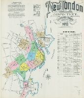
62. New London, New London County, Connecticut.
- Creator:
- Sanborn-Perris Map Co., issuing body
- Published / Created:
- 1891
- Call Number:
- 766 N47 1891
- Image Count:
- 17
- Resource Type:
- Maps, Atlases & Globes
- Abstract:
- Sanborn fire insurance maps are a rich source of historic data on the urban built environment of North America during the 19th and early 20th centuries. The atlases were created for the purpose of underwriting fire insurance policies, which depended upon accurate and frequently-updated information about construction materials, municipal and transportation infrastructure, industrial and commercial landuse and more. The Yale University Library Map Department scanned its holdings of Sanborn fire insurance maps (consisting primarily of Connecticut towns) in order to make the maps more accessible.
- Alternative Title:
- Mar. 1891, New London, Conn.
- Description:
- "17 sheets. (4334).", Contains information on population, prevailing winds, water facilities and fire department., Includes index of streets and specials., Partial cadastral map., and SMLMAPL 766 N47 1891: Sheets disbound. "Triplicate" stamp on all sheets. Library of Congress copyright stamp on title sheet.
- Subject (Geographic):
- New London (Conn.)--Maps
- Subject (Name):
- Library of Congress Stamp
- Subject (Topic):
- Fire risk assessment--Connecticut--New London--Maps and Real property--Connecticut--New London--Maps
- Found in:
- Beinecke Rare Book and Manuscript Library > New London, New London County, Connecticut.