Skip to search
Skip to main content
Skip to first result
Search
You Searched For
Format
cartographic
Subject (Topic)
World War, 1914-1918--Maps
New Search
Search Results
Published / Created:
191-.
Call Number:
11hcf 1919A-31
Container / Volume:
BRBL_00010N
Image Count:
2
Resource Type:
Maps, Atlases & Globes
Description:
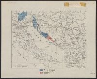
Shows territories "delimited by the Treaty of London" and "additional territory claimed in this memorandum."
Publisher:
s.n.,
Subject (Geographic):
Italy--Maps
Subject (Topic):
World War, 1914-1918--Maps
Found in:
Beinecke Rare Book and Manuscript Library > [Italian claims along the Adriatic Sea.]
Published / Created:
ca. 1914?]
Call Number:
30am 1914A
Container / Volume:
BRBL_00037
Image Count:
1
Resource Type:
Maps, Atlases & Globes
Description:
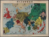
"No. 32". and In Russian, Japanese and English.
Subject (Geographic):
Europe--Maps
Subject (Topic):
World War, 1914-1918--Maps
Found in:
Beinecke Rare Book and Manuscript Library > [Pictorial war map, in Russian.]
Published / Created:
[1915?]
Call Number:
11hcf 1919A-32
Container / Volume:
BRBL_00010N
Image Count:
1
Resource Type:
Maps, Atlases & Globes
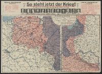
Alternative Title:
Pola, Zara, Comacchio
Description:
"B.4." in upper left margin., "Teilweise berichtigt bis I. V. 1915.", and Stamped "American Geographical Society" above left margin and "Loaned by the American Geographical Society, Broadway at 136th St., New York to The Peace Conference at Versailles 1918-1919
Publisher:
K.u.K. Militär geographisches Institut,
Subject (Geographic):
Croatia--Maps and Italy--Maps
Subject (Topic):
World War, 1914-1918--Maps
Found in:
Beinecke Rare Book and Manuscript Library > [Regional map of the area around the Adriatic Sea : showing the cities of Pola, Zara, Comacchio] / K.u.K. Militärgeographisches Institut.
Branch:v1.61.8 ,Deployed:2024-06-20T11:15:04-04:00